IMAGES TAKEN NEAR TO
Main Road, SHREWSBURY, SY5 7JS
Introduction
This page details the photographs taken nearby to Main Road, SY5 7JS by members of the Geograph project.
The Geograph project started in 2005 with the aim of publishing, organising and preserving representative images for every square kilometre of Great Britain, Ireland and the Isle of Man.

There are currently over 7.5m images from over14,400 individuals and you can help contribute to the project by visiting https://www.geograph.org.uk
Image Map
Images are licensed for reuse under creativecommons.org/licenses/by-sa/2.0
Notes
- Clicking on the map will re-center to the selected point.
- The higher the marker number, the further away the image location is from the centre of the postcode.
Image Listing (41 Images Found)
Images are licensed for reuse under creativecommons.org/licenses/by-sa/2.0
Image
Details
Distance
1
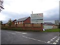
Building site and its hoarding, Dorrington
A new housing estate on the south of the village. The estate is named: The Farr's. It is named after William Farr, a British epidemiologist considered one of the founders of medical statistics. Born in Shropshire in 1807, Farr lived in Dorrington where his impoverished family received safe housing by a local Squire, Joseph Pryce. Pryce’s legacy allowed Farr to study medicine in France and Switzerland. Returning to England and following further studies, he started a medical practice in Fitzroy Square, London. There he became involved in medical journalism and along with his contributions to cholera and tuberculosis research made his mark on the world of medical statistics.
Image: © David Smith
Taken: 20 Oct 2017
0.04 miles
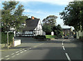
2
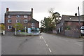
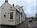
Dorrington, Looking South along the A49
If you are passing this way, call into the Butchers shop, you won't be disappointed.
Image: © Mick Malpass
Taken: 3 Nov 2013
0.05 miles
3
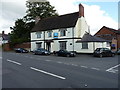
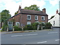
Grove Farmhouse, Dorrington
Probably a late 16th or early 17th century, timber-framed farmhouse but brick-faced in the mid 18th century - traces of the earlier construction are visible internally, especially in the roof. It was Grade II listed https://www.britishlistedbuildings.co.uk/101366657-grove-farmhouse-condover#.Wbri69QrLGg in 1986. It has traded as a public house or inn, but is now converted back to residential use.
Image: © Richard Law
Taken: 2 Sep 2017
0.06 miles
4
Sadd's Butchers, Dorrington
This shop has fascinated me every time I pass it, with huge hams hanging in its window. One of these days I'll stop and shop.
Image: © Eirian Evans
Taken: 31 May 2008
0.07 miles
5
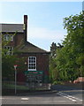
The Old Post Office, Dorrington
A mid-19th century house, which for some while served as the village PO and shop, but has now reverted to residential use. It was given a Grade II listing https://www.britishlistedbuildings.co.uk/101055669-the-old-post-office-attached-gate-piers-and-railings-condover#.WbrkK9QrLGg in 1986, along with the gatepiers and railings.
Image: © Richard Law
Taken: 2 Sep 2017
0.07 miles
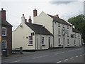
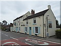
7
The Horseshoes
The inn has been repainted since the picture Image] was taken two years ago.
Image: © David Smith
Taken: 20 Oct 2010
0.08 miles
8
A49 passes Dorrington Old Hall
The establishment used to be called 'Country Friends' but has metamorphosed into a Persian restaurant. The building itself is no stranger to change either, originating as it does in the late 17th C. It is Grade II listed with English Heritage Building ID: 259400.Structurally there are considerable later additions and alterations, principally of late 19th and 20th C. See also: http://www.britishlistedbuildings.co.uk/en-259400-country-friends-restaurant-condover-shropshire
Image: © Stuart Logan
Taken: 20 Sep 2013
0.08 miles
9
A49 and Dorrington Horseshoes pub
The A49 was first named as such in 1923. It runs North-South through the Welsh Marches.
Image: © Bikeboy
Taken: 10 Apr 2014
0.08 miles
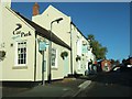
10
The Horseshoes at Dorrington, Shropshire
Lovely village pub and roadside eatery.
Image: © Jeremy Bolwell
Taken: 10 Jul 2019
0.09 miles