IMAGES TAKEN NEAR TO
Church Road, SHREWSBURY, SY5 7JL
Introduction
This page details the photographs taken nearby to Church Road, SY5 7JL by members of the Geograph project.
The Geograph project started in 2005 with the aim of publishing, organising and preserving representative images for every square kilometre of Great Britain, Ireland and the Isle of Man.

There are currently over 7.5m images from over14,400 individuals and you can help contribute to the project by visiting https://www.geograph.org.uk
Image Map
Images are licensed for reuse under creativecommons.org/licenses/by-sa/2.0
Notes
- Clicking on the map will re-center to the selected point.
- The higher the marker number, the further away the image location is from the centre of the postcode.
Image Listing (42 Images Found)
Images are licensed for reuse under creativecommons.org/licenses/by-sa/2.0
Image
Details
Distance
1
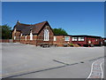
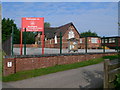
Dorrington Primary School
A lovely Victorian brick building, with a couple of wooden demountables attached to the back. They don't do a lot for the place...
Image: © Richard Law
Taken: 23 May 2010
0.03 miles
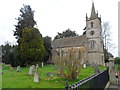
3
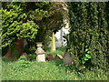
Churchyard, St Edward's Church, Dorrington
Image: © Eirian Evans
Taken: 31 May 2008
0.04 miles
4
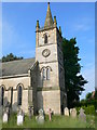
Church tower, Dorrington
The tower of St Edward's Church
Image: © Eirian Evans
Taken: 31 May 2008
0.04 miles
6
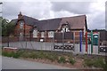
Dorrington School
Church of England School, as is common in Shropshire.
Image: © Richard Webb
Taken: 31 Jul 2016
0.05 miles
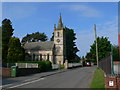
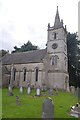
7
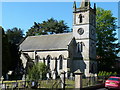
St Edward's Church, Dorrington
Built in 1845. Designed by the Shropshire architect, Edward Haycock, who also designed Lord Hill's Column at Shrewsbury. See http://www.geograph.org.uk/photo/51542
Image: © Bikeboy
Taken: 10 Apr 2014
0.05 miles
10
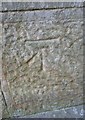
Ordnance Survey Cut Mark
This OS cut mark can be found on the west face of St Edward's Church. It marks a point 112.058m above mean sea level.
Image: © Adrian Dust
Taken: 2 Oct 2016
0.06 miles