IMAGES TAKEN NEAR TO
Fernbrook, SHREWSBURY, SY5 7HY
Introduction
This page details the photographs taken nearby to Fernbrook, SY5 7HY by members of the Geograph project.
The Geograph project started in 2005 with the aim of publishing, organising and preserving representative images for every square kilometre of Great Britain, Ireland and the Isle of Man.

There are currently over 7.5m images from over14,400 individuals and you can help contribute to the project by visiting https://www.geograph.org.uk
Image Map
Images are licensed for reuse under creativecommons.org/licenses/by-sa/2.0
Notes
- Clicking on the map will re-center to the selected point.
- The higher the marker number, the further away the image location is from the centre of the postcode.
Image Listing (53 Images Found)
Images are licensed for reuse under creativecommons.org/licenses/by-sa/2.0
Image
Details
Distance
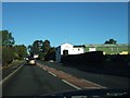
3
Erozone, Dorrington Business Park
Industrial estate in Dorrington. Home of a surviving bit of what was once a major industry in South Shropshire, clothes making - in this case lingerie.
Image: © Richard Webb
Taken: 30 Jul 2009
0.03 miles
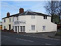
4
Dorrington Business Park
A sign on the end wall announces that there are units to let.
Image: © David Smith
Taken: 20 Oct 2010
0.04 miles
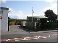
5
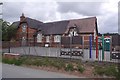
Dorrington School
Church of England School, as is common in Shropshire.
Image: © Richard Webb
Taken: 31 Jul 2016
0.04 miles
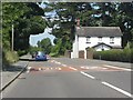
6
Old Toll House by the A49, Main Road, Dorrington
Toll House in the parish of Condover, at the junction of Main Road (A49) and Station Road, Dorrington.
To be surveyed
Milestone Society National ID: SA.CON
Image: © Milestone Society
Taken: Unknown
0.05 miles

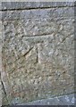
8
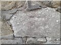
Ordnance Survey Cut Mark
This very worn OS cut mark can be found on the wall SE side of Station Road. It marks a point 110.560m above mean sea level.
Image: © Adrian Dust
Taken: 5 Jul 2023
0.05 miles
9
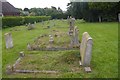
Churchyard, Dorrington
St Edwards Church, Dorrington.
Image: © Richard Webb
Taken: 31 Jul 2016
0.06 miles
10
Ordnance Survey Cut Mark
This OS cut mark can be found on the west face of St Edward's Church. It marks a point 112.058m above mean sea level.
Image: © Adrian Dust
Taken: 2 Oct 2016
0.06 miles