IMAGES TAKEN NEAR TO
Millfield Place, SY5 7ES
Introduction
This page details the photographs taken nearby to Millfield Place, SY5 7ES by members of the Geograph project.
The Geograph project started in 2005 with the aim of publishing, organising and preserving representative images for every square kilometre of Great Britain, Ireland and the Isle of Man.

There are currently over 7.5m images from over14,400 individuals and you can help contribute to the project by visiting https://www.geograph.org.uk
Image Map
Images are licensed for reuse under creativecommons.org/licenses/by-sa/2.0
Notes
- Clicking on the map will re-center to the selected point.
- The higher the marker number, the further away the image location is from the centre of the postcode.
Image Listing (43 Images Found)
Images are licensed for reuse under creativecommons.org/licenses/by-sa/2.0
Image
Details
Distance
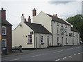
1
Dorrington houses
Half-timbered house on the main street in Dorrington.
Image: © Eirian Evans
Taken: 25 Sep 2010
0.03 miles
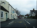
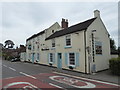
2
A49 and Dorrington Horseshoes pub
The A49 was first named as such in 1923. It runs North-South through the Welsh Marches.
Image: © Bikeboy
Taken: 10 Apr 2014
0.05 miles
4
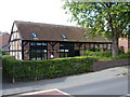
The Forge, Dorrington
A former smithy and stables, dating from the early 17th century and Grade II listed https://www.britishlistedbuildings.co.uk/101366639-the-forge-condover#.WbrlGtQrLGg in 1978, at which time it was derelict, so what we see now is a sensitive restoration.
Image: © Richard Law
Taken: 2 Sep 2017
0.05 miles
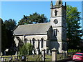
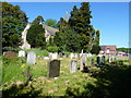
6
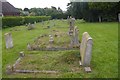
Churchyard, Dorrington
St Edwards Church, Dorrington.
Image: © Richard Webb
Taken: 31 Jul 2016
0.06 miles
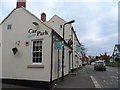
8
The Horseshoes at Dorrington, Shropshire
Lovely village pub and roadside eatery.
Image: © Jeremy Bolwell
Taken: 10 Jul 2019
0.06 miles
9
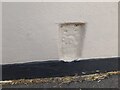
Ordnance Survey Flush Bracket (2867)
This OS Flush Bracket can be found on The Horseshoes Inn. It marks a point 108.810m above mean sea level.
Image: © Adrian Dust
Taken: 5 Jul 2023
0.06 miles