IMAGES TAKEN NEAR TO
Hunger Hill, SHREWSBURY, SY5 7BJ
Introduction
This page details the photographs taken nearby to Hunger Hill, SY5 7BJ by members of the Geograph project.
The Geograph project started in 2005 with the aim of publishing, organising and preserving representative images for every square kilometre of Great Britain, Ireland and the Isle of Man.

There are currently over 7.5m images from over14,400 individuals and you can help contribute to the project by visiting https://www.geograph.org.uk
Image Map
Images are licensed for reuse under creativecommons.org/licenses/by-sa/2.0
Notes
- Clicking on the map will re-center to the selected point.
- The higher the marker number, the further away the image location is from the centre of the postcode.
Image Listing (12 Images Found)
Images are licensed for reuse under creativecommons.org/licenses/by-sa/2.0
Image
Details
Distance
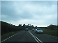
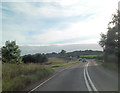
1
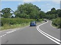
A49 at Chatbrook
The junction for Stapleton is on the left, on a blind bend.
Image: © Peter Whatley
Taken: 6 Jul 2013
0.05 miles
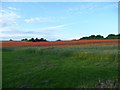
2
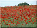
Poppy field on a June evening
Reminiscent of Monet's 'Poppies at Argenteuill' this field is densely packed with flowers even during the evening.
Image: © Jeremy Bolwell
Taken: 20 Jun 2010
0.06 miles
3
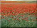
Poppies in a Shropshire meadow
Scarlet and crimson haze in an evening poppyfield.
Image: © Jeremy Bolwell
Taken: 20 Jun 2010
0.06 miles
4
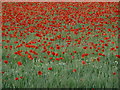
Poppyfield at evening
Poppies in the cooling evening air.
Image: © Jeremy Bolwell
Taken: 20 Jun 2010
0.06 miles
6
Poppies in the evening sunlight
This field is adjacent to the A49. I asked the landowner's permission before I took this photo and he was amenable - however I would not recommend straying off the footpath here as he was built like a bulldog, with a temperament to match.
Image: © Jeremy Bolwell
Taken: 20 Jun 2010
0.08 miles