IMAGES TAKEN NEAR TO
Eaton Constantine, SHREWSBURY, SY5 6SQ
Introduction
This page details the photographs taken nearby to SY5 6SQ by members of the Geograph project.
The Geograph project started in 2005 with the aim of publishing, organising and preserving representative images for every square kilometre of Great Britain, Ireland and the Isle of Man.

There are currently over 7.5m images from over14,400 individuals and you can help contribute to the project by visiting https://www.geograph.org.uk
Image Map (Loading...)


Getting Data...Please wait
Leaflet Map data © OpenStreetMap
Images are licensed for reuse under creativecommons.org/licenses/by-sa/2.0
Notes
- Clicking on the map will re-center to the selected point.
- The higher the marker number, the further away the image location is from the centre of the postcode.
Image Listing (5 Images Found)
Images are licensed for reuse under creativecommons.org/licenses/by-sa/2.0
Image
Details
Distance
2
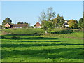
Footpath alongside the Severn at Eye Farm
Image: © Richard Law
Taken: 10 Oct 2010
0.13 miles
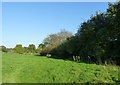
3
Gate and stile at field boundary
Looking SW along public footpath and at a gate and stile at field boundary
Image: © Rob Bainbridge
Taken: 9 Feb 2023
0.14 miles
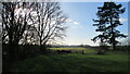
4
Severnside footpath and The Wrekin
A public footpath from Cressage to Leighton runs through the fields of Leighton Hall estate, with views of the Severn and The Wrekin
Image: © Richard Law
Taken: 10 Oct 2010
0.14 miles
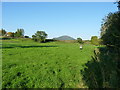
5
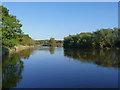
The Severn near Eye Farm
Prince Albert Angling Association water on The Severn at Leighton.
Image: © Richard Law
Taken: 10 Oct 2010
0.24 miles