IMAGES TAKEN NEAR TO
Eaton Constantine, SHREWSBURY, SY5 6RD
Introduction
This page details the photographs taken nearby to SY5 6RD by members of the Geograph project.
The Geograph project started in 2005 with the aim of publishing, organising and preserving representative images for every square kilometre of Great Britain, Ireland and the Isle of Man.

There are currently over 7.5m images from over14,400 individuals and you can help contribute to the project by visiting https://www.geograph.org.uk
Image Map (Loading...)


Getting Data...Please wait
Leaflet Map data © OpenStreetMap
Images are licensed for reuse under creativecommons.org/licenses/by-sa/2.0
Notes
- Clicking on the map will re-center to the selected point.
- The higher the marker number, the further away the image location is from the centre of the postcode.
Image Listing (10 Images Found)
Images are licensed for reuse under creativecommons.org/licenses/by-sa/2.0
Image
Details
Distance
1
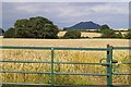
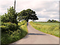
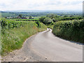
Ripening wheat near Dryton
The large hill in the background is The Wrekin.
Image: © Peter Craine
Taken: 22 Jul 2007
0.11 miles
2
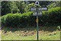
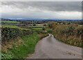
Direction Sign - Signpost by the B4380, The Coalpits
Annulus finial - 4 Worboys arms; Shropshire CC modern halo by the UC road, in parish of Wroxeter and Uppington (Shrewsbury and Atcham District), Lower Longwood.
Surveyed
Milestone Society National ID: SA_SJ5806
Image: © Milestone Society
Taken: Unknown
0.15 miles
10
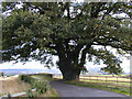
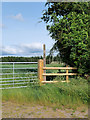
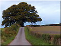
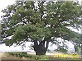
Ancient oak.
On a minor road 586065 - view is across the Severn Valley.
Image: © Bob Bowyer
Taken: 1 Sep 2005
0.23 miles