IMAGES TAKEN NEAR TO
Wroxeter, SHREWSBURY, SY5 6PY
Introduction
This page details the photographs taken nearby to SY5 6PY by members of the Geograph project.
The Geograph project started in 2005 with the aim of publishing, organising and preserving representative images for every square kilometre of Great Britain, Ireland and the Isle of Man.

There are currently over 7.5m images from over14,400 individuals and you can help contribute to the project by visiting https://www.geograph.org.uk
Image Map (Loading...)


Getting Data...Please wait
Leaflet Map data © OpenStreetMap
Images are licensed for reuse under creativecommons.org/licenses/by-sa/2.0
Notes
- Clicking on the map will re-center to the selected point.
- The higher the marker number, the further away the image location is from the centre of the postcode.
Image Listing (3 Images Found)
Images are licensed for reuse under creativecommons.org/licenses/by-sa/2.0
Image
Details
Distance
1

The Wythyns
B4380 to Leighton as it passes the house called 'The Wythyns'.
Image: © Row17
Taken: 16 Mar 2008
0.02 miles
2
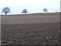
A Field With Trees in the Hedge
This cultivated field has a hedge which is home to these mature trees which appear to be growing at regular intervals in the hedge.
Image: © Michael Patterson
Taken: 23 Feb 2007
0.12 miles
3

Field beside the B4380
The hills on the horizon are; The Lawley & Caer Caradoc.
Image: © Row17
Taken: 16 Mar 2008
0.18 miles