IMAGES TAKEN NEAR TO
Wroxeter, SHREWSBURY, SY5 6PU
Introduction
This page details the photographs taken nearby to SY5 6PU by members of the Geograph project.
The Geograph project started in 2005 with the aim of publishing, organising and preserving representative images for every square kilometre of Great Britain, Ireland and the Isle of Man.

There are currently over 7.5m images from over14,400 individuals and you can help contribute to the project by visiting https://www.geograph.org.uk
Image Map (Loading...)


Getting Data...Please wait
Leaflet Map data © OpenStreetMap
Images are licensed for reuse under creativecommons.org/licenses/by-sa/2.0
Notes
- Clicking on the map will re-center to the selected point.
- The higher the marker number, the further away the image location is from the centre of the postcode.
Image Listing (2 Images Found)
Images are licensed for reuse under creativecommons.org/licenses/by-sa/2.0
Image
Details
Distance
1
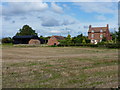
Donnington Farm
Across the cropped wheatfield to Donnington Farm
Image: © Richard Law
Taken: 18 Sep 2010
0.15 miles
2
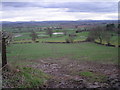
The Severn Valley from Charlton Hill
The hills in the distance, just off centre right, are The Breiddens. Located between Shrewsbury & Welshpool.
Image: © Row17
Taken: 16 Mar 2008
0.25 miles