IMAGES TAKEN NEAR TO
Kenley, SHREWSBURY, SY5 6NJ
Introduction
This page details the photographs taken nearby to SY5 6NJ by members of the Geograph project.
The Geograph project started in 2005 with the aim of publishing, organising and preserving representative images for every square kilometre of Great Britain, Ireland and the Isle of Man.

There are currently over 7.5m images from over14,400 individuals and you can help contribute to the project by visiting https://www.geograph.org.uk
Image Map (16 Images)


Getting Data...Please wait
Leaflet Map data © OpenStreetMap
Images are licensed for reuse under creativecommons.org/licenses/by-sa/2.0
Notes
- Clicking on the map will re-center to the selected point.
- The higher the marker number, the further away the image location is from the centre of the postcode.
Image Listing (16 Images Found)
Images are licensed for reuse under creativecommons.org/licenses/by-sa/2.0
Image
Details
Distance
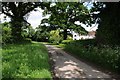
2
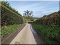
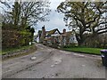
Narrow lane from Kenley
Heading down the hill from Kenley on the lane that runs, eventually, into Acton Burnell.
Image: © Richard Law
Taken: 16 Dec 2014
0.09 miles
4
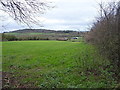
Country road passing Bull Farm
Country road passing Bull Farm near Kenley.
Image: © Philip Halling
Taken: 1 Jun 2018
0.16 miles
5
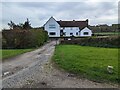
Bull Farm Cottages
I believe this was originally two cottages but is now one.
Image: © TCExplorer
Taken: 12 Apr 2024
0.18 miles
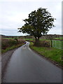
6
Bull Farm
A name that is uncommon I think.
Image: © Jeremy Bolwell
Taken: 9 Mar 2021
0.19 miles
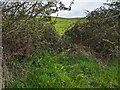
8
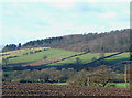
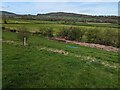
Farmland and Hillside, near Kenley, Shropshire
Image: © Roger D Kidd
Taken: 10 Dec 2007
0.20 miles
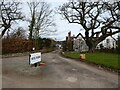
9
Bull Farm, Kenley
Home of the Wild family.
Image: © TCExplorer
Taken: 12 Apr 2024
0.20 miles