IMAGES TAKEN NEAR TO
Kenley, SHREWSBURY, SY5 6NF
Introduction
This page details the photographs taken nearby to SY5 6NF by members of the Geograph project.
The Geograph project started in 2005 with the aim of publishing, organising and preserving representative images for every square kilometre of Great Britain, Ireland and the Isle of Man.

There are currently over 7.5m images from over14,400 individuals and you can help contribute to the project by visiting https://www.geograph.org.uk
Image Map
Images are licensed for reuse under creativecommons.org/licenses/by-sa/2.0
Notes
- Clicking on the map will re-center to the selected point.
- The higher the marker number, the further away the image location is from the centre of the postcode.
Image Listing (7 Images Found)
Images are licensed for reuse under creativecommons.org/licenses/by-sa/2.0
Image
Details
Distance
1
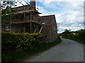
Building or refurbishment work underway at Wyres Barn
Image: © Richard Law
Taken: 13 May 2012
0.02 miles
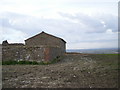
4
Wyres Barn
Is the building in the centre. The buildings of Little Bloomcroft are partly visible on the left.
Image: © Jennifer Luther Thomas
Taken: 1 Dec 2006
0.05 miles
5
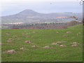
Mountain & Molehills
At only 401 metres The Wrekin isn't really a mountain but it's the nearest we've got to one.
Image: © Row17
Taken: 26 Mar 2008
0.09 miles
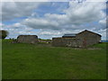
6
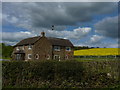
Cottage at Broomcroft
A lucky shot - the summer's housemartins have arrived at their nesting grounds just east of Broomcroft Farm.
Image: © Richard Law
Taken: 13 May 2012
0.15 miles
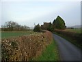
7
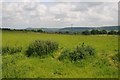
View to Wenlock Edge
View to Wenlock Edge across a field and farmland near Kenley.
Image: © Philip Halling
Taken: 1 Jun 2018
0.16 miles