IMAGES TAKEN NEAR TO
Eaton Mascott, Cross Houses, SHREWSBURY, SY5 6HE
Introduction
This page details the photographs taken nearby to SY5 6HE by members of the Geograph project.
The Geograph project started in 2005 with the aim of publishing, organising and preserving representative images for every square kilometre of Great Britain, Ireland and the Isle of Man.

There are currently over 7.5m images from over14,400 individuals and you can help contribute to the project by visiting https://www.geograph.org.uk
Image Map
Images are licensed for reuse under creativecommons.org/licenses/by-sa/2.0
Notes
- Clicking on the map will re-center to the selected point.
- The higher the marker number, the further away the image location is from the centre of the postcode.
Image Listing (8 Images Found)
Images are licensed for reuse under creativecommons.org/licenses/by-sa/2.0
Image
Details
Distance
1
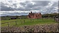
Newmans Hall Cottages, Berrington
Grade II listed farmhouse
Image: © TCExplorer
Taken: 25 Mar 2023
0.00 miles
2

View towards the Shropshire Hills
Beyond Newmans Hall Cottages, you can see the hills of Caer Caradoc and The Lawley.
Image: © TCExplorer
Taken: 12 May 2023
0.12 miles
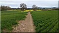
4
Footpath to Berrington
This footpath climbs over the hill on its way to Berrington.
Image: © Michael Patterson
Taken: 5 Apr 2006
0.20 miles
5
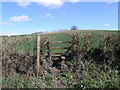
Footpath gap in the hedge
Quite a steep slope between the fields, very slippery when wet.
Image: © TCExplorer
Taken: 16 Apr 2023
0.22 miles
6
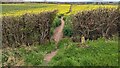
Footpath from Berrington to Eaton Mascott
A nice fragrant smell in the air at this time of year
Image: © TCExplorer
Taken: 16 Apr 2023
0.22 miles
7
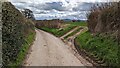
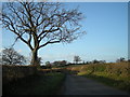
Lane from Berrington to Eaton Mascott
Along this lane the hedges are typically much higher than your head; the lane is sunken compared to the fields so you can't see much of the fields.
Image: © TCExplorer
Taken: 25 Mar 2023
0.24 miles
8
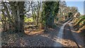
Start of byway to Little Pitchford
The path branches off from the road to the left and goes through a small patch of woodland before a footbridge crosses Cound Brook.
Image: © Andrew Abbott
Taken: 13 Feb 2023
0.25 miles