IMAGES TAKEN NEAR TO
Russell Place, SHREWSBURY, SY5 6EY
Introduction
This page details the photographs taken nearby to Russell Place, SY5 6EY by members of the Geograph project.
The Geograph project started in 2005 with the aim of publishing, organising and preserving representative images for every square kilometre of Great Britain, Ireland and the Isle of Man.

There are currently over 7.5m images from over14,400 individuals and you can help contribute to the project by visiting https://www.geograph.org.uk
Image Map
Images are licensed for reuse under creativecommons.org/licenses/by-sa/2.0
Notes
- Clicking on the map will re-center to the selected point.
- The higher the marker number, the further away the image location is from the centre of the postcode.
Image Listing (46 Images Found)
Images are licensed for reuse under creativecommons.org/licenses/by-sa/2.0
Image
Details
Distance
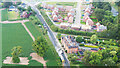
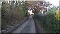
1
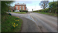
View of the lane to Berrington and Russell Place
Looking west towards Shrewsbury along the A458 at the western end of the village of Cross Houses in Shropshire.
Image: © Andrew Abbott
Taken: 26 Mar 2021
0.01 miles
2
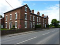
Russell Place, Berrington
Built around 1830-1840 as a terrace of houses, and Grade II listed https://britishlistedbuildings.co.uk/101176971-russel-place-berrington#.XSbWvehKhPY & https://historicengland.org.uk/listing/the-list/list-entry/1176971 in 1986.
Image: © Richard Law
Taken: 27 May 2019
0.01 miles
4
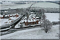
Russell Place in the snow
A snowy scene on the edge of Cross Houses, looking towards Berrington. The final houses of Phase 2 of the Berrington Meadows development on the left can be seen in construction.
Image: © TCExplorer
Taken: 24 Jan 2021
0.02 miles
5

Bedford RLHZ 'Green Goddess' Self Propelled Pump
The 'Green Goddess' as they were colloquially known was a fire engine built between 1953 and 1956. Here it is the lead vehicle in 'Clara's Classic Convoy' raising money for Hope House hospice.
Image: © TCExplorer
Taken: 29 Sep 2024
0.02 miles
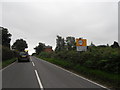
6
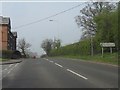
Resurfacing the A458
Getting a coating of new stone chips early in the morning under a full road closure.
Image: © Andrew Abbott
Taken: 20 Jul 2021
0.02 miles
8
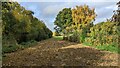
Looking west by the former Severn Valley Railway line (disused)
Just past the old bridge by Berrington station, this shows the entrance to a narrow field in Cross Houses (typically used for Sweetcorn for local anaerobic digestion), with the line of the old Severn Valley Railway following the trees in the left-hand part of the image. The railway line is overgrown and emerges from a cutting to meet with the level of the surrounding fields in the distance of the photo.
Image: © Andrew Abbott
Taken: 25 Oct 2022
0.06 miles
9
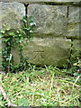
OS benchmark - Cross Houses, railway bridge
An OS cutmark on the parapet wall of the bridge over the disused railway, which was levelled in 1967 at 70.994m above Ordnance Datum Newlyn.
Image: © Richard Law
Taken: 27 May 2019
0.07 miles
10
Berrington Lane, old railway bridge
Unclassified road from Crosshouses to Berrington, you can see the railway bridge parapets.
Image: © Rob Bainbridge
Taken: 6 Dec 2022
0.07 miles