IMAGES TAKEN NEAR TO
Meadow Close, SHREWSBURY, SY5 6DU
Introduction
This page details the photographs taken nearby to Meadow Close, SY5 6DU by members of the Geograph project.
The Geograph project started in 2005 with the aim of publishing, organising and preserving representative images for every square kilometre of Great Britain, Ireland and the Isle of Man.

There are currently over 7.5m images from over14,400 individuals and you can help contribute to the project by visiting https://www.geograph.org.uk
Image Map (Loading...)


Getting Data...Please wait
Leaflet Map data © OpenStreetMap
Images are licensed for reuse under creativecommons.org/licenses/by-sa/2.0
Notes
- Clicking on the map will re-center to the selected point.
- The higher the marker number, the further away the image location is from the centre of the postcode.
Image Listing (45 Images Found)
Images are licensed for reuse under creativecommons.org/licenses/by-sa/2.0
Image
Details
Distance
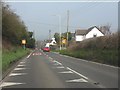
1
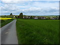
The southern side of Cressage
Taken from the main track to New Buildings Farm
Image: © Richard Law
Taken: 13 May 2012
0.05 miles
3
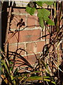
OS benchmark - Cressage, 37 Harley Road
An OS cutmark on the south wall of no 37; originally levelled at 69.473m above Ordnance Datum Newlyn.
Image: © Richard Law
Taken: 16 Dec 2014
0.11 miles
5
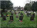
Cressage Graveyard
The graveyard in Cressage is in a square to the south of the one that most of the church stands in.
Image: © Michael Patterson
Taken: 23 Feb 2007
0.14 miles
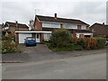
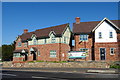
6
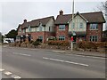
2 & 3 Church Grange, Cressage
New houses built in 2017 - 2018.
Image: © TCExplorer
Taken: 6 Nov 2024
0.14 miles
8
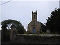
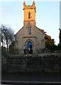
Christchurch in Cressage
Striking church.
Image: © Jeremy Bolwell
Taken: 7 Jan 2022
0.15 miles
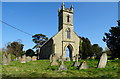
10
Christ Church, Cressage
The ancient church in Cressage was a chapelry of Cound and was dedicated to St Sampson. Its position close to the river made it liable to flooding and so in 1841 it was replaced by this present building sited somewhat farther from the water. The exact whereabouts of the original church are lost.
Image: © Eirian Evans
Taken: 8 Jan 2011
0.15 miles