IMAGES TAKEN NEAR TO
Venus Bank, SHREWSBURY, SY5 6AL
Introduction
This page details the photographs taken nearby to Venus Bank, SY5 6AL by members of the Geograph project.
The Geograph project started in 2005 with the aim of publishing, organising and preserving representative images for every square kilometre of Great Britain, Ireland and the Isle of Man.

There are currently over 7.5m images from over14,400 individuals and you can help contribute to the project by visiting https://www.geograph.org.uk
Image Map
Images are licensed for reuse under creativecommons.org/licenses/by-sa/2.0
Notes
- Clicking on the map will re-center to the selected point.
- The higher the marker number, the further away the image location is from the centre of the postcode.
Image Listing (16 Images Found)
Images are licensed for reuse under creativecommons.org/licenses/by-sa/2.0
Image
Details
Distance
1
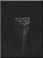
Milepost by old railway bridge
Below "SALOP 6" the legend says "TO THE COUNTY HALL".
Image: © Jennifer Luther Thomas
Taken: 1 Dec 2006
0.01 miles
2
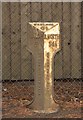
Old Milepost by the A458, Venusbank, Cound Parish
Cast iron post by the A458, in parish of COUND (SHREWSBURY AND ATCHAM District), Venusbank; 50m North of No. 39, by the road, on South West side of road. Erected by the Shrewsbury to Bridgnorth turnpike trust in the 19th century.
Inscription reads:-
: SALOP / 6 / (vertical) TO THE COUNTY HALL : : WENLOCK / 6½ : : B.NORTH / 14½ / (vertical) TO THE TOWN HALL :
Grade II Listed. List Entry Number: 1177371
https://historicengland.org.uk/listing/the-list/list-entry/1177371
Milestone Society National ID: SA_SBBN06.
Image: © A Reade/J Higgins
Taken: 2 Jun 2008
0.04 miles
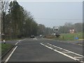
3
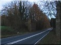
Deckless bridge
The abutments of the former bridge of the Bridgnorth to Shrewsbury railway line crossing the A458 Bridgnorth to Shrewsbury road.
Image: © Jennifer Luther Thomas
Taken: 1 Dec 2006
0.05 miles
4

OS benchmark - Venusbank railway bridge
An OS cutmark in the stonework of the disused railway bridge; originally levelled at 47.503m above Ordnance Datum Newlyn.
Image: © Richard Law
Taken: 4 Jan 2015
0.05 miles
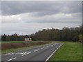
5

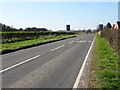
No missing that
The words on the road are there for a reason - it's a tight(ish) chicane out of the other side of the disused bridge.
Image: © Richard Law
Taken: 4 Jan 2015
0.07 miles
9
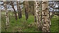
Trees along former Severn Valley Railway line
This used to be a railway line, but trees have long since been planted in straight lines along the former track bed.
Image: © TCExplorer
Taken: 16 Apr 2023
0.22 miles