IMAGES TAKEN NEAR TO
Cound, SHREWSBURY, SY5 6AE
Introduction
This page details the photographs taken nearby to SY5 6AE by members of the Geograph project.
The Geograph project started in 2005 with the aim of publishing, organising and preserving representative images for every square kilometre of Great Britain, Ireland and the Isle of Man.

There are currently over 7.5m images from over14,400 individuals and you can help contribute to the project by visiting https://www.geograph.org.uk
Image Map (Loading...)


Getting Data...Please wait
Leaflet Map data © OpenStreetMap
Images are licensed for reuse under creativecommons.org/licenses/by-sa/2.0
Notes
- Clicking on the map will re-center to the selected point.
- The higher the marker number, the further away the image location is from the centre of the postcode.
Image Listing (14 Images Found)
Images are licensed for reuse under creativecommons.org/licenses/by-sa/2.0
Image
Details
Distance
2

Leasowes
I assume the missing bricks in this farm building are nesting holes for doves?
Image: © Michael Patterson
Taken: 14 Feb 2007
0.14 miles
3
Severn Valley Bridge No. 77.
Bridge over the dismantled part of the GWR Severn Valley railway line.
Image: © Row17
Taken: 6 Mar 2008
0.17 miles
4
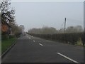
A458 towards Shrewsbury
Looking north west near Leasowes.
Image: © JThomas
Taken: 28 Mar 2019
0.18 miles
5
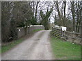
Bridge spanning the former Bridgnorth to Shrewsbury railway line
Severn Valley Bridge No. 77.
Image: © JThomas
Taken: 28 Mar 2019
0.19 miles
6
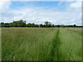
A riverside meadow at Eyton
Not an easy place to get to - a mile of wading through rather damp, knee-high grass along the Point-to-Point course. If you picked a day when they were racing, it might be easier, but I didn't!
Image: © Richard Law
Taken: 7 Jul 2012
0.20 miles
7
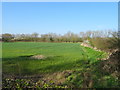
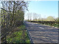
Crop field and hedgerow
Off the A458.
The line of trees at the bottom marks the line of a disused railway (Bridgnorth to Shrewsbury line).
Image: © JThomas
Taken: 28 Mar 2019
0.20 miles
8
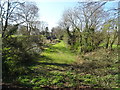
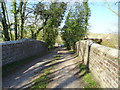
Course of the former Bridgnorth to Shrewsbury railway line
Image: © JThomas
Taken: 28 Mar 2019
0.21 miles
9
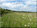
The Point-to-Point course east of Ferry Meadow
This large field, known as Ferry Meadow, is so named because of the river crossing that operated in conjunction with the railway line on the other side of the Severn until the 1960s. It gave the residents of Eyton and nearby places access to the Buildwas to Shrewsbury line.
Image: © Richard Law
Taken: 7 Jul 2012
0.22 miles
10
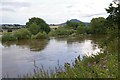
River Severn
As seen from the Riverside Inn. The river is in flood. The hill in the background is the Wrekin.
Image: © Peter Craine
Taken: 22 Jul 2007
0.22 miles