IMAGES TAKEN NEAR TO
Pontesbury Hill, SHREWSBURY, SY5 0YD
Introduction
This page details the photographs taken nearby to Pontesbury Hill, SY5 0YD by members of the Geograph project.
The Geograph project started in 2005 with the aim of publishing, organising and preserving representative images for every square kilometre of Great Britain, Ireland and the Isle of Man.

There are currently over 7.5m images from over14,400 individuals and you can help contribute to the project by visiting https://www.geograph.org.uk
Image Map (Loading...)


Getting Data...Please wait
Leaflet Map data © OpenStreetMap
Images are licensed for reuse under creativecommons.org/licenses/by-sa/2.0
Notes
- Clicking on the map will re-center to the selected point.
- The higher the marker number, the further away the image location is from the centre of the postcode.
Image Listing (5 Images Found)
Images are licensed for reuse under creativecommons.org/licenses/by-sa/2.0
Image
Details
Distance
1
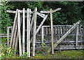
New finger posts
These new posts are waiting to be taken to their new locations in Shropshire,
this will be done by the Shropshire Access Maintenance Team based at Old Nills Quarry.
Image: © Dave Croker
Taken: 9 Sep 2009
0.07 miles
2
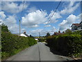
Lane between Poles Coppice and Pontesbury
Some gorgeous houses - and gardens - up this lane.
Image: © Jeremy Bolwell
Taken: 17 May 2021
0.17 miles