IMAGES TAKEN NEAR TO
Rantipol Lane, SHREWSBURY, SY5 0XN
Introduction
This page details the photographs taken nearby to Rantipol Lane, SY5 0XN by members of the Geograph project.
The Geograph project started in 2005 with the aim of publishing, organising and preserving representative images for every square kilometre of Great Britain, Ireland and the Isle of Man.

There are currently over 7.5m images from over14,400 individuals and you can help contribute to the project by visiting https://www.geograph.org.uk
Image Map (7 Images)


Getting Data...Please wait
Leaflet Map data © OpenStreetMap
Images are licensed for reuse under creativecommons.org/licenses/by-sa/2.0
Notes
- Clicking on the map will re-center to the selected point.
- The higher the marker number, the further away the image location is from the centre of the postcode.
Image Listing (7 Images Found)
Images are licensed for reuse under creativecommons.org/licenses/by-sa/2.0
Image
Details
Distance
2
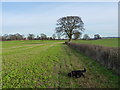
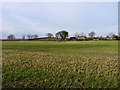
Wandered off the footpath by mistake
Due to some careless route plotting, we took a detour from the public paths west of here, and did a circuit of this field to reach the lane near Arscott Villa
Image: © Richard Law
Taken: 28 Jan 2012
0.07 miles
3
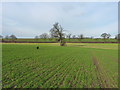
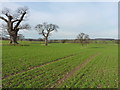
Properly daft dog in a field near Arscott
Slightly off the footpath, but enjoying the freedom of a run in a field of winter wheat near Arscott.
Image: © Richard Law
Taken: 28 Jan 2012
0.08 miles
4
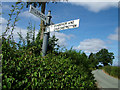
Signpost at Arscott
A signpost on the approach to Arscott village.
Image: © Simon Norman
Taken: 23 Jul 2006
0.16 miles