IMAGES TAKEN NEAR TO
Habberley, Pontesbury, SHREWSBURY, SY5 0TS
Introduction
This page details the photographs taken nearby to SY5 0TS by members of the Geograph project.
The Geograph project started in 2005 with the aim of publishing, organising and preserving representative images for every square kilometre of Great Britain, Ireland and the Isle of Man.

There are currently over 7.5m images from over14,400 individuals and you can help contribute to the project by visiting https://www.geograph.org.uk
Image Map (Loading...)


Getting Data...Please wait
Leaflet Map data © OpenStreetMap
Images are licensed for reuse under creativecommons.org/licenses/by-sa/2.0
Notes
- Clicking on the map will re-center to the selected point.
- The higher the marker number, the further away the image location is from the centre of the postcode.
Image Listing (18 Images Found)
Images are licensed for reuse under creativecommons.org/licenses/by-sa/2.0
Image
Details
Distance
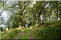
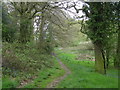
2
Track and footpath heading north into Poles Coppice
Footpath beautifully lined with wood anemones.
Image: © Andrew Shannon
Taken: 6 Apr 2022
0.12 miles
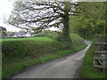
3

Lane near Bank Farm near Habberley, Shropshire
Looks like a nice farm.
Image: © Jeremy Bolwell
Taken: 17 May 2021
0.12 miles
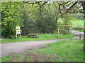
4

Footpath crosses the lane
An interesting rural cross roads.
Image: © Jeremy Bolwell
Taken: 17 May 2021
0.13 miles
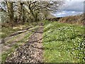
5

Footpath and track
And quite muddy after recent rains.
Image: © Jeremy Bolwell
Taken: 17 May 2021
0.13 miles
9

Footpath through field
South of Poles Coppice.
Image: © John H Darch
Taken: 10 Jul 2020
0.18 miles