IMAGES TAKEN NEAR TO
Hall Bank, SHREWSBURY, SY5 0RF
Introduction
This page details the photographs taken nearby to Hall Bank, SY5 0RF by members of the Geograph project.
The Geograph project started in 2005 with the aim of publishing, organising and preserving representative images for every square kilometre of Great Britain, Ireland and the Isle of Man.

There are currently over 7.5m images from over14,400 individuals and you can help contribute to the project by visiting https://www.geograph.org.uk
Image Map
Images are licensed for reuse under creativecommons.org/licenses/by-sa/2.0
Notes
- Clicking on the map will re-center to the selected point.
- The higher the marker number, the further away the image location is from the centre of the postcode.
Image Listing (33 Images Found)
Images are licensed for reuse under creativecommons.org/licenses/by-sa/2.0
Image
Details
Distance
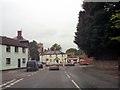
4
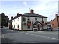
The Red Lion, Pontesbury
Greenalls pub with Tetleys the usual tipple
Image: © al partington
Taken: 20 Sep 2007
0.10 miles
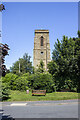
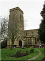
6
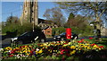
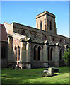
Pontesbury - St George's Church & flower border
Image: © Colin Park
Taken: 8 Apr 2017
0.10 miles
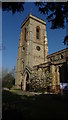
9
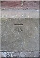
Ordnance Survey Cut Mark
This OS cut mark can be found on the south face of St George's Church. It marks a point 111.698m above mean sea level.
Image: © Adrian Dust
Taken: 12 May 2016
0.11 miles