IMAGES TAKEN NEAR TO
Snailbeach, SHREWSBURY, SY5 0LT
Introduction
This page details the photographs taken nearby to SY5 0LT by members of the Geograph project.
The Geograph project started in 2005 with the aim of publishing, organising and preserving representative images for every square kilometre of Great Britain, Ireland and the Isle of Man.

There are currently over 7.5m images from over14,400 individuals and you can help contribute to the project by visiting https://www.geograph.org.uk
Image Map (Loading...)


Getting Data...Please wait
Leaflet Map data © OpenStreetMap
Images are licensed for reuse under creativecommons.org/licenses/by-sa/2.0
Notes
- Clicking on the map will re-center to the selected point.
- The higher the marker number, the further away the image location is from the centre of the postcode.
Image Listing (32 Images Found)
Images are licensed for reuse under creativecommons.org/licenses/by-sa/2.0
Image
Details
Distance
1
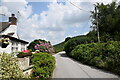
Roadside cottage with flowers...
...just south of Snailbeach.
Image: © Bill Harrison
Taken: 22 Jul 2021
0.15 miles
2
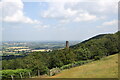
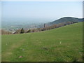
Footpath above Snailbeach and it's chimney
A well known view to any walkers in this area...
Image: © Jeremy Bolwell
Taken: 7 Mar 2020
0.17 miles
3
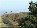
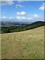
Upland scene below the Stiperstones
Moorland grasses, heather, gorse and fir trees in early morning sunshine en route to the summit ridge.
Image: © Jeremy Bolwell
Taken: 18 Apr 2010
0.17 miles
4
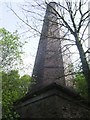
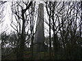
Octagonal chimney above Snailbeach Mine
The chimney dates from the late 1850s and connects to flues from the boiler house adjacent to the 1300ft deep Lordswood Shaft.
Image: © John M
Taken: 25 Apr 2011
0.18 miles
5

Deciduous woodland on Resting Hill
The lower slopes of Resting Hill above Snailbeach are covered with deciduous woodland. View from the public footpath ascending the hill from Snailbeach
Image: © Espresso Addict
Taken: 17 Apr 2010
0.19 miles
6
Looking towards Snailbeach...
...including a former mine chimney and in the distance the village of Minsterley.
Image: © Bill Harrison
Taken: 22 Jul 2021
0.19 miles
7
Towards Resting Hill Chimney
A footpath across open fields above Resting Hill Chimney Image, which is part of the Snailbeach Lead Mines complex.
Image: © Richard Law
Taken: 21 Aug 2011
0.19 miles
8
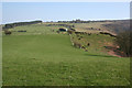
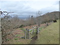
Pasture-moorland boundary on Resting Hill
The fence (right & centre) divides lush sheep pasture (left) from moorland (right), at an elevation of around 340 metres near the summit of Resting Hill
Image: © Espresso Addict
Taken: 17 Apr 2010
0.19 miles
9
Chimney above Snailbeach mine
Today this chimney surveys the disused lead mine site near the footpath up to the Stiperstones.
Image: © Jeremy Bolwell
Taken: 18 Apr 2010
0.19 miles
10
Snailbeach chimney
The footpath here offers a prospect over the Snailbeach area.
Image: © Jeremy Bolwell
Taken: 18 Apr 2010
0.21 miles