IMAGES TAKEN NEAR TO
Waterwheel, Minsterley, SHREWSBURY, SY5 0HY
Introduction
This page details the photographs taken nearby to SY5 0HY by members of the Geograph project.
The Geograph project started in 2005 with the aim of publishing, organising and preserving representative images for every square kilometre of Great Britain, Ireland and the Isle of Man.

There are currently over 7.5m images from over14,400 individuals and you can help contribute to the project by visiting https://www.geograph.org.uk
Image Map
Images are licensed for reuse under creativecommons.org/licenses/by-sa/2.0
Notes
- Clicking on the map will re-center to the selected point.
- The higher the marker number, the further away the image location is from the centre of the postcode.
Image Listing (13 Images Found)
Images are licensed for reuse under creativecommons.org/licenses/by-sa/2.0
Image
Details
Distance
1
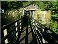
Footpath bridge at The Waterwheel
Footpath leads into stream side cottages’ back gardens
Image: © Andrew Shannon
Taken: 4 Nov 2021
0.02 miles
2
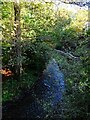
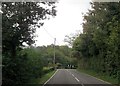
Stream running alongside the A488 at The Waterwheel
Must have been the driver of the named Waterwheel - long since disappeared. This stream finds its way north to join the Rea Brook a few miles further on.
Image: © Andrew Shannon
Taken: 4 Nov 2021
0.02 miles
3
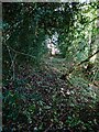
Little used footpath off the A488 south of Wagbeach
Leads up into pastureland, hillside, and on this occasion a visual encounter with a surprised roaming fox.
Image: © Andrew Shannon
Taken: 4 Nov 2021
0.06 miles
4
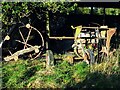
Long discarded farm equipment
Most farms have these nostalgic graveyards
Image: © Andrew Shannon
Taken: 4 Nov 2021
0.09 miles
6
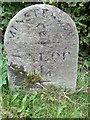
Old Milestone by the A488, Minsterley parish
Carved stone post by the A488, in parish of MINSTERLEY (SHREWSBURY AND ATCHAM District), The Waterwheel, by Misty Dawn, on East side of road. Erected by the Shrewsbury to Minsterley turnpike trust in the 19th century.
Inscription reads:-
MINSTERLEY
2
SALOP
11¼
Grade II listed.
List Entry Number: 1055225 https://historicengland.org.uk/listing/the-list/list-entry/1055225
Milestone Society National ID: SA_SBBC11.
Image: © A Reade
Taken: 11 May 2005
0.11 miles

8
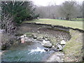
The power of erosion
The small river in the Hope Valley has a lot of force to undermine the bank.
Image: © Jonathan Billinger
Taken: 3 Jan 2008
0.17 miles
9
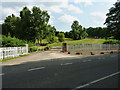
The fairly grandiose entrance to Hogstow Hall
Image: © Richard Law
Taken: 13 Jul 2013
0.18 miles
10
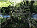
Little used and dilapidated footbridge
South of The Waterwheel, gaining access to the track leading up to Hogstow Hall
Image: © Andrew Shannon
Taken: 4 Nov 2021
0.19 miles