IMAGES TAKEN NEAR TO
Orchid Meadow, SHREWSBURY, SY5 0FB
Introduction
This page details the photographs taken nearby to Orchid Meadow, SY5 0FB by members of the Geograph project.
The Geograph project started in 2005 with the aim of publishing, organising and preserving representative images for every square kilometre of Great Britain, Ireland and the Isle of Man.

There are currently over 7.5m images from over14,400 individuals and you can help contribute to the project by visiting https://www.geograph.org.uk
Image Map (Loading...)


Getting Data...Please wait
Leaflet Map data © OpenStreetMap
Images are licensed for reuse under creativecommons.org/licenses/by-sa/2.0
Notes
- Clicking on the map will re-center to the selected point.
- The higher the marker number, the further away the image location is from the centre of the postcode.
Image Listing (14 Images Found)
Images are licensed for reuse under creativecommons.org/licenses/by-sa/2.0
Image
Details
Distance
2

Minsterley Play Area
Adjacent to housing on the east side of the village, and a safe distance from the main road.
Image: © Jonathan Billinger
Taken: 3 Jan 2008
0.15 miles
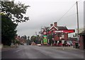
5

The Crown & Sceptre pub, Minsterley
A proper local pub.
Image: © Jeremy Bolwell
Taken: 2 May 2012
0.21 miles

7

Minsterley, Texaco Garage on Station Road
Image: © David Dixon
Taken: 11 Apr 2016
0.21 miles
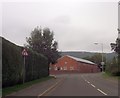
8

Minsterley Garage
A Texaco filling station in the village, linked to a small Co-operative store.
Image: © David Smith
Taken: 29 Nov 2014
0.22 miles
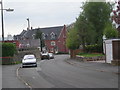
10
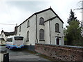
The Congregational chapel in Minsterley
Dated 1833, the year this chapel separated from the Baptist movement, the Baptist's leaving on good terms to build their new chapel at Lordshill near Snailbeach. The upper floor here was the schoolroom. The building looks like it may still be in use, but maybe not.
Image: © Jeremy Bolwell
Taken: 2 May 2012
0.23 miles