IMAGES TAKEN NEAR TO
Malehurst Industrial Estate, SHREWSBURY, SY5 0EQ
Introduction
This page details the photographs taken nearby to Malehurst Industrial Estate, SY5 0EQ by members of the Geograph project.
The Geograph project started in 2005 with the aim of publishing, organising and preserving representative images for every square kilometre of Great Britain, Ireland and the Isle of Man.

There are currently over 7.5m images from over14,400 individuals and you can help contribute to the project by visiting https://www.geograph.org.uk
Image Map (Loading...)


Getting Data...Please wait
Leaflet Map data © OpenStreetMap
Images are licensed for reuse under creativecommons.org/licenses/by-sa/2.0
Notes
- Clicking on the map will re-center to the selected point.
- The higher the marker number, the further away the image location is from the centre of the postcode.
Image Listing (5 Images Found)
Images are licensed for reuse under creativecommons.org/licenses/by-sa/2.0
Image
Details
Distance
2
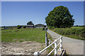
Malhurst Farm
Modern farm buildings at Malhurst farm
Image: © P Gaskell
Taken: Unknown
0.17 miles
3
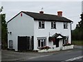
Poulton Toll House, Pontesbury
Toll House by the A488, in the parish of Pontesbury, The Gate House.
Shropshire HER.
HER Number (PRN): 15402 https://www.heritagegateway.org.uk/Gateway/Results_Single.aspx?uid=MSA18337&resourceID=1015
To be surveyed
Milestone Society National ID: SA.POU
Image: © Milestone Society
Taken: Unknown
0.18 miles
4

Approaching road junction near Malehurst Bank
Image: © John Firth
Taken: 26 Sep 2013
0.20 miles
