IMAGES TAKEN NEAR TO
Etsell, Minsterley, SHREWSBURY, SY5 0DW
Introduction
This page details the photographs taken nearby to SY5 0DW by members of the Geograph project.
The Geograph project started in 2005 with the aim of publishing, organising and preserving representative images for every square kilometre of Great Britain, Ireland and the Isle of Man.

There are currently over 7.5m images from over14,400 individuals and you can help contribute to the project by visiting https://www.geograph.org.uk
Image Map
Images are licensed for reuse under creativecommons.org/licenses/by-sa/2.0
Notes
- Clicking on the map will re-center to the selected point.
- The higher the marker number, the further away the image location is from the centre of the postcode.
Image Listing (3 Images Found)
Images are licensed for reuse under creativecommons.org/licenses/by-sa/2.0
Image
Details
Distance
1
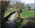
The farm with a new name
On my old 1st edition Landranger map (1974) this was shown as Estell Farm but the name on the gate and on the latest OS map is Etsell, showing that the gradual changing of place-names is a continuing process.
Image: © Stephen Craven
Taken: 24 Dec 2007
0.15 miles