IMAGES TAKEN NEAR TO
Station Road, SHREWSBURY, SY5 0BD
Introduction
This page details the photographs taken nearby to Station Road, SY5 0BD by members of the Geograph project.
The Geograph project started in 2005 with the aim of publishing, organising and preserving representative images for every square kilometre of Great Britain, Ireland and the Isle of Man.

There are currently over 7.5m images from over14,400 individuals and you can help contribute to the project by visiting https://www.geograph.org.uk
Image Map (Loading...)


Getting Data...Please wait
Leaflet Map data © OpenStreetMap
Images are licensed for reuse under creativecommons.org/licenses/by-sa/2.0
Notes
- Clicking on the map will re-center to the selected point.
- The higher the marker number, the further away the image location is from the centre of the postcode.
Image Listing (52 Images Found)
Images are licensed for reuse under creativecommons.org/licenses/by-sa/2.0
Image
Details
Distance
1
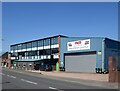
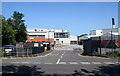
Rea Valley corned beef processing plant, Minsterley
Image: © Bill Harrison
Taken: 17 Jul 2021
0.01 miles
3
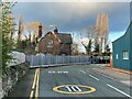
Minsterley railway station (site), Shropshire
Opened in 1861 by the London & North Western Railway as the terminus of the short branch line from Hanwood, this station closed to passengers in 1951 and completely in 1967.
View north from the road at the station forecourt, now a private residence. The platform was behind and to the right of the house, at a right-angle to this viewpoint. It is now under a car park and factory buildings.
Image: © Nigel Thompson
Taken: 10 Dec 2021
0.05 miles
5

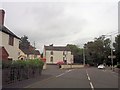
The Crown & Sceptre pub, Minsterley
A proper local pub.
Image: © Jeremy Bolwell
Taken: 2 May 2012
0.08 miles
7
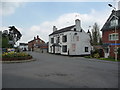
The Bridge Hotel in Minsterley
Yet another closure, a victim of our times.
Image: © Jeremy Bolwell
Taken: 2 May 2012
0.09 miles
8
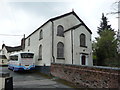
The Congregational chapel in Minsterley
Dated 1833, the year this chapel separated from the Baptist movement, the Baptist's leaving on good terms to build their new chapel at Lordshill near Snailbeach. The upper floor here was the schoolroom. The building looks like it may still be in use, but maybe not.
Image: © Jeremy Bolwell
Taken: 2 May 2012
0.09 miles
9

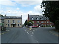
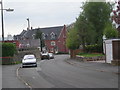
Village centre, Minsterley
The small roundabout where the B4499 diverges from the A488. The end of Minsterley parish church can be seen beyond the bridge.
Image: © Bill Harrison
Taken: 17 Jul 2021
0.09 miles