IMAGES TAKEN NEAR TO
Maple Drive, SHREWSBURY, SY5 0AU
Introduction
This page details the photographs taken nearby to Maple Drive, SY5 0AU by members of the Geograph project.
The Geograph project started in 2005 with the aim of publishing, organising and preserving representative images for every square kilometre of Great Britain, Ireland and the Isle of Man.

There are currently over 7.5m images from over14,400 individuals and you can help contribute to the project by visiting https://www.geograph.org.uk
Image Map (Loading...)


Getting Data...Please wait
Leaflet Map data © OpenStreetMap
Images are licensed for reuse under creativecommons.org/licenses/by-sa/2.0
Notes
- Clicking on the map will re-center to the selected point.
- The higher the marker number, the further away the image location is from the centre of the postcode.
Image Listing (17 Images Found)
Images are licensed for reuse under creativecommons.org/licenses/by-sa/2.0
Image
Details
Distance
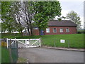
1
A488 entering Minsterley at Fire Station
Fire station is to the left
Image: © John Firth
Taken: 26 Sep 2013
0.02 miles
2
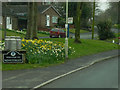
Welcome to Minsterley
Village sign at the side of the A488.
Image: © David Dixon
Taken: 11 Apr 2016
0.02 miles
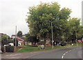
3

Minsterley fire station
Minsterley fire station, Little Minsterley, Minsterley, Shropshire
Image: © Kevin Hale
Taken: 29 Oct 2007
0.05 miles
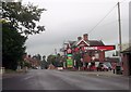
5
Minsterley, Texaco Garage on Station Road
Image: © David Dixon
Taken: 11 Apr 2016
0.10 miles
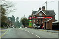
7

Minsterley Garage
A Texaco filling station in the village, linked to a small Co-operative store.
Image: © David Smith
Taken: 29 Nov 2014
0.11 miles
8

Minsterley dairy seen from the A488 on the east
Slightly screened by the trees, but still visible from the road
Image: © David Smith
Taken: 29 Nov 2014
0.12 miles
9
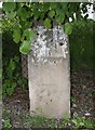
Old Milestone by the A488, Little Minsterley
Stone post (plate lost) by the A488, in parish of MINSTERLEY (SHREWSBURY AND ATCHAM District), Little Minsterley, by Telephone exchange, on South East side of road. Bishops Castle arched stone, erected by the Bishops Castle turnpike trust in the 19th century.
Inscription once read:- : (Shrewsbury 9) :
Carved benchmark front lower middle.
Shropshire HER listed. HER Number (PRN): 21145
https://www.heritagegateway.org.uk/Gateway/Results_Single.aspx?uid=MSA23744&resourceID=1015
Milestone Society National ID: SA_SBBC09.
Image: © A Reade/J Higgins
Taken: 11 May 2005
0.12 miles