IMAGES TAKEN NEAR TO
Lee Hill, SHREWSBURY, SY4 5RZ
Introduction
This page details the photographs taken nearby to Lee Hill, SY4 5RZ by members of the Geograph project.
The Geograph project started in 2005 with the aim of publishing, organising and preserving representative images for every square kilometre of Great Britain, Ireland and the Isle of Man.

There are currently over 7.5m images from over14,400 individuals and you can help contribute to the project by visiting https://www.geograph.org.uk
Image Map
Images are licensed for reuse under creativecommons.org/licenses/by-sa/2.0
Notes
- Clicking on the map will re-center to the selected point.
- The higher the marker number, the further away the image location is from the centre of the postcode.
Image Listing (51 Images Found)
Images are licensed for reuse under creativecommons.org/licenses/by-sa/2.0
Image
Details
Distance
2
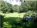
Sports field at Lee Brockhurst
A clearing in the woods given over, it appears, to a variety of activities including hockey, golf, canoeing and a children's play area.
Image: © Oliver Dixon
Taken: 9 Sep 2020
0.02 miles
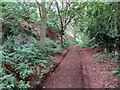
3
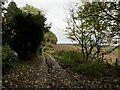
The Roman Road, Lee Brockhurst
Gives access to the paths in the woods to the west as well as several delightfully located houses.
Image: © Richard Webb
Taken: 12 Nov 2021
0.02 miles

5
Snowdrops on the wooded slopes north of Lee Brockhurst village
Love these modest harbingers of Spring!
Image: © Jeremy Bolwell
Taken: 7 Feb 2021
0.05 miles
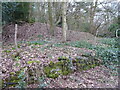
6
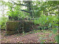
Ruined sandstone structure near Lee Brockhurst
Ruined sandstone structure, possibly an animal pen, on wooded hill near Lee Brockhurst.
Image: © Lorna Lyons
Taken: 10 Sep 2012
0.07 miles
8
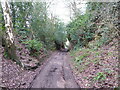
Old Roman road north of Lee Brockhurst village
Part of the Roman road linking Wroxeter / Viroconium with Whitchurch / Mediolanum.
There is a veritable network of ancient routes in and around this area. Many might even pre-date Roman rule. As might this.
Image: © Jeremy Bolwell
Taken: 7 Feb 2021
0.08 miles

10
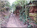
Part of an old Roman road out of Lee Brockhurst
Carved down through the underlying bedrock here of Old Red Sandstone. I imagine it being excavated by slave labour or prisoners after the Roman conquest of the area, immediately being put to work to Romanise the area and install a better road network, but the subject of much grumbling and a slow work rate by the unwilling new Roman subjects.
Though I saw no graffiti saying Romani ite domum! https://www.youtube.com/watch?v=IIAdHEwiAy8
Image: © Jeremy Bolwell
Taken: 7 Feb 2021
0.10 miles