IMAGES TAKEN NEAR TO
Canal Close, SHREWSBURY, SY4 4TR
Introduction
This page details the photographs taken nearby to Canal Close, SY4 4TR by members of the Geograph project.
The Geograph project started in 2005 with the aim of publishing, organising and preserving representative images for every square kilometre of Great Britain, Ireland and the Isle of Man.

There are currently over 7.5m images from over14,400 individuals and you can help contribute to the project by visiting https://www.geograph.org.uk
Image Map
Images are licensed for reuse under creativecommons.org/licenses/by-sa/2.0
Notes
- Clicking on the map will re-center to the selected point.
- The higher the marker number, the further away the image location is from the centre of the postcode.
Image Listing (58 Images Found)
Images are licensed for reuse under creativecommons.org/licenses/by-sa/2.0
Image
Details
Distance
1
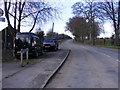
Church Road
The road out of Uffington village towards the Newport Road and the A49.
Image: © Gordon Griffiths
Taken: 18 Mar 2011
0.01 miles
4

Course of the Shrewsbury Canal
The start of the cycleway into Shrewsbury.
Image: © John M
Taken: 19 Sep 2009
0.04 miles
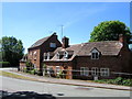
5
Canal Cottage view
The view of Church Road in Uffington near the disused Shrewsbury Canal.
Image: © Gordon Griffiths
Taken: 18 Mar 2011
0.05 miles
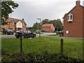
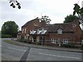
6
The last houses in Uffington
Or first, if you are approaching from the North.
Image: © John H Darch
Taken: 29 May 2020
0.06 miles
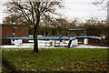
7
Uffington Wharf - Shrewsbury Canal
The road used to rise up to cross a hump-back bridge over the canal in the picture foreground. In old photographs the buildings are largely hidden from view by the bridge. This is one of a number of obstacles facing the Shrewsbury and Newport Canals Trust.
Image: © John M
Taken: 19 Sep 2009
0.08 miles
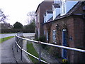
8
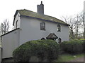
Cottage in Uffington
Uffington has many fine properties.
Image: © Jeremy Bolwell
Taken: 7 Mar 2021
0.09 miles
9
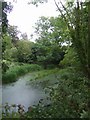
Shrewsbury Canal
A section in water near Uffington Wharf.
Image: © John M
Taken: 19 Sep 2009
0.09 miles
10
Uffington No. 2
There are two similar installations in the same compound: Uffington nos 1 & 2. I'm grateful to Chris Hodrien for the following information about it.
This is a gas pipeline pressure reduction station, known 'in the trade' as an 'AGI' (Above-Ground Installation, where (usually) PART of the total gas flow is branched-off at a lower pressure for the local towns and industry. There are several 100 such offtake points on the GB mainland. The pressure reduction/regulation valves are in the brick building on the left to protect them from the weather. This is a (standard UK) special explosion-resistant safety building with a lightweight roof that completely lifts-off to vent explosion pressures. (Gas compressor stations on the 70 bar high-pressure National Transmission System (NTS) are much bigger affairs, with gas engine-driven centrifugal compressors in large weather-proof containers).
Image: © Mike White
Taken: 10 Dec 2010
0.09 miles