IMAGES TAKEN NEAR TO
Uffington, SHREWSBURY, SY4 4TH
Introduction
This page details the photographs taken nearby to SY4 4TH by members of the Geograph project.
The Geograph project started in 2005 with the aim of publishing, organising and preserving representative images for every square kilometre of Great Britain, Ireland and the Isle of Man.

There are currently over 7.5m images from over14,400 individuals and you can help contribute to the project by visiting https://www.geograph.org.uk
Image Map
Images are licensed for reuse under creativecommons.org/licenses/by-sa/2.0
Notes
- Clicking on the map will re-center to the selected point.
- The higher the marker number, the further away the image location is from the centre of the postcode.
Image Listing (14 Images Found)
Images are licensed for reuse under creativecommons.org/licenses/by-sa/2.0
Image
Details
Distance
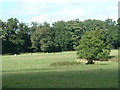
1
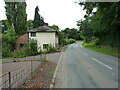
Pre-Worboys direction sign at Berwick Wharf
Berwick Wharf is a small settlement on the banks of the former Shrewsbury Canal (later part of the Shropshire Union system).
Image: © Christopher Hilton
Taken: 29 Jan 2023
0.01 miles
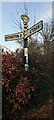
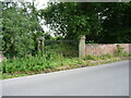
2
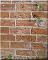
OS benchmark - Berwick Wharf, roadside wall
An OS cutmark on the brick wall to the SE of the road junction, last levelled in 1967 at 58.011m above Ordnance Datum Newlyn.
Image: © Richard Law
Taken: 21 Jul 2020
0.02 miles
3
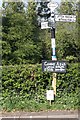
Old Direction Sign - Signpost by Berwick Wharf, Atcham parish
Half-moon finial - 3 arms; Shropshire parish fan by the UC road, in parish of Atcham (Shrewsbury and Atcham District), Berwick Wharf, Grove Cottages.
Surveyed
Milestone Society National ID: SA_SJ5410
Image: © Milestone Society
Taken: Unknown
0.02 miles
5
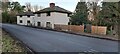
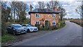
Houses at Berwick Wharf
Between the two houses, a track leads down to the course of the old Shrewsbury Canal; the houses may have been part of a wharf complex.
Image: © Christopher Hilton
Taken: 29 Jan 2023
0.05 miles
7
The northern gateway to Attingham Park
Gate piers and wrought-iron gates, which date from around 1806, and which form the now-disused entranceway into the Attingham estate. They were Grade II listed https://britishlistedbuildings.co.uk/101366933-north-gates-and-gate-piers-to-attingham-park-atcham#.Yk6LsMjMI2w & https://historicengland.org.uk/listing/the-list/list-entry/1366933 in 1985.
Image: © Richard Law
Taken: 21 Jul 2020
0.08 miles
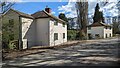
9
Nos 3 & 4, Berwick Wharf
Former canal workers' cottages, dating from the late 18th or early 19th century. They lie immediately south of the route of the Shrewsbury arm of the Shropshire Union canal, which operated between 1797 and 1944, and were collectively Grade II listed https://britishlistedbuildings.co.uk/101176899-3-and-4-berwick-wharf-atcham#.Yk17ycjMI2w & https://historicengland.org.uk/listing/the-list/list-entry/1176899 in 1985. The exposed timber framing is a very late implementation of the construction technique, which is more commonly associated with older (16th/17th century) cottages.
Image: © Richard Law
Taken: 21 Jul 2020
0.08 miles