IMAGES TAKEN NEAR TO
Uffington, SHREWSBURY, SY4 4TG
Introduction
This page details the photographs taken nearby to SY4 4TG by members of the Geograph project.
The Geograph project started in 2005 with the aim of publishing, organising and preserving representative images for every square kilometre of Great Britain, Ireland and the Isle of Man.

There are currently over 7.5m images from over14,400 individuals and you can help contribute to the project by visiting https://www.geograph.org.uk
Image Map
Images are licensed for reuse under creativecommons.org/licenses/by-sa/2.0
Notes
- Clicking on the map will re-center to the selected point.
- The higher the marker number, the further away the image location is from the centre of the postcode.
Image Listing (3 Images Found)
Images are licensed for reuse under creativecommons.org/licenses/by-sa/2.0
Image
Details
Distance
1
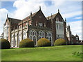
Longner Hall
Nash House with Gothick Plasterwork in Repton Landscape Home the Burtons since time out of mind.
Thanks HHA
Image: © Graham Burnett
Taken: 7 May 2007
0.03 miles
2
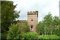
Folly Tower, Longner Hall
A small folly tower just to the side of Longner hall and attached to a curving castellated wall
Image: © Alan Terrill
Taken: 22 May 2011
0.05 miles
3
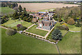
Longner Hall
Grade I listed Regency Gothic house by John Nash, designed in 1803, set in a park landscaped by Humphrey Repton.
Sometimes open to the public.
Home to the Burton family, which owns huge swathes of the surrounding land.
Image: © TCExplorer
Taken: 20 Apr 2023
0.07 miles