IMAGES TAKEN NEAR TO
Preston On Severn, SHREWSBURY, SY4 4TF
Introduction
This page details the photographs taken nearby to Preston On Severn, SY4 4TF by members of the Geograph project.
The Geograph project started in 2005 with the aim of publishing, organising and preserving representative images for every square kilometre of Great Britain, Ireland and the Isle of Man.

There are currently over 7.5m images from over14,400 individuals and you can help contribute to the project by visiting https://www.geograph.org.uk
Image Map
Images are licensed for reuse under creativecommons.org/licenses/by-sa/2.0
Notes
- Clicking on the map will re-center to the selected point.
- The higher the marker number, the further away the image location is from the centre of the postcode.
Image Listing (12 Images Found)
Images are licensed for reuse under creativecommons.org/licenses/by-sa/2.0
Image
Details
Distance
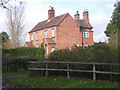
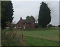
1
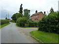
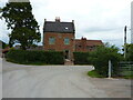
New Villas at Preston Boats
The same buildings that are seen in Image, with the lane back towards Preston Farm in the foreground.
Image: © Richard Law
Taken: 21 Jul 2020
0.01 miles
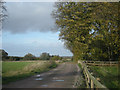
5
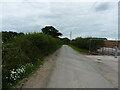
NE along the lane at Preston Boats
Looking away from the hamlet & farm in the general direction of Haughmond Hill.
Image: © Richard Law
Taken: 21 Jul 2020
0.10 miles
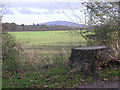
6
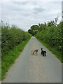
Eastwards along the lane out of Preston
Image: © Richard Law
Taken: 21 Jul 2020
0.11 miles
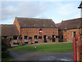
8
Tunnel Cottages - Shrewsbury Canal
Near the entrance to the Berwick Tunnel.
Image: © John M
Taken: 19 Sep 2009
0.17 miles
9
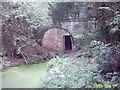
Berwick tunnel, the Shrewsbury canal
This is the disused Berwick canal tunnel (north side) on the Shrewsbury canal.
Image: © Mr M Evison
Taken: 4 Sep 2004
0.17 miles