IMAGES TAKEN NEAR TO
Hunkington Lane, SHREWSBURY, SY4 4RS
Introduction
This page details the photographs taken nearby to Hunkington Lane, SY4 4RS by members of the Geograph project.
The Geograph project started in 2005 with the aim of publishing, organising and preserving representative images for every square kilometre of Great Britain, Ireland and the Isle of Man.

There are currently over 7.5m images from over14,400 individuals and you can help contribute to the project by visiting https://www.geograph.org.uk
Image Map
Images are licensed for reuse under creativecommons.org/licenses/by-sa/2.0
Notes
- Clicking on the map will re-center to the selected point.
- The higher the marker number, the further away the image location is from the centre of the postcode.
Image Listing (5 Images Found)
Images are licensed for reuse under creativecommons.org/licenses/by-sa/2.0
Image
Details
Distance
1
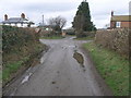
Not a Happy Road
In fact it is a crossroads! Sorry. The roads lead to Upton Magna, Somerwood, Rodington and Withington. The Give Way sign has morphed into the hedge.
Image: © Michael Patterson
Taken: 23 Feb 2007
0.12 miles
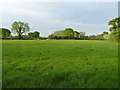
4
Good luck following the bridleway
The right of way across this field has been completely ploughed out.
Image: © Richard Law
Taken: 7 May 2019
0.22 miles
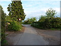
5
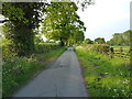
Cyclists on Drury Lane
A lovely evening for a pootle on the lanes of Shropshire. I was out for a walk with the dogs, so it wasn't a bad alternative to a ride.
Image: © Richard Law
Taken: 7 May 2019
0.24 miles