IMAGES TAKEN NEAR TO
Haughmond, Uffington, SHREWSBURY, SY4 4RP
Introduction
This page details the photographs taken nearby to SY4 4RP by members of the Geograph project.
The Geograph project started in 2005 with the aim of publishing, organising and preserving representative images for every square kilometre of Great Britain, Ireland and the Isle of Man.

There are currently over 7.5m images from over14,400 individuals and you can help contribute to the project by visiting https://www.geograph.org.uk
Image Map
Images are licensed for reuse under creativecommons.org/licenses/by-sa/2.0
Notes
- Clicking on the map will re-center to the selected point.
- The higher the marker number, the further away the image location is from the centre of the postcode.
Image Listing (31 Images Found)
Images are licensed for reuse under creativecommons.org/licenses/by-sa/2.0
Image
Details
Distance
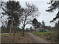
1
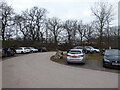
Part of the car park at Haughmond Hill, next to the quarry
Cars park here in serried ranks as families enjoy the hill and next door legions of quarry trucks await their loads and rev and splutter in the cold morning air.
Image: © Jeremy Bolwell
Taken: 7 Mar 2021
0.05 miles
2
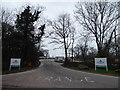
Quarry road entrance at Haughmond Hill
Quarried for road building aggregates, hard wearing rocks and a fascinating operation.
Image: © Jeremy Bolwell
Taken: 7 Mar 2021
0.06 miles
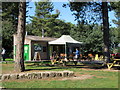
5
Cafe at the car park at Haughmond Hill
The car park is jammed with walkers and visitors, such is the popularity of the amenities here, especially during the current lockdown, when outdoor exercise, mental health, socially distanced meet-ups and well-being are on everyone's minds.
When I was here a mature lady slipped face first on some mud and we had a laugh about the dangers of venturing outdoors for health and well-being!
Image: © Jeremy Bolwell
Taken: 7 Mar 2021
0.10 miles
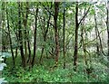
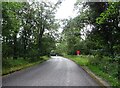
8
Haughmond Hill
Haughmond Hill woodland is in the care of the Forestry Commission.
Image: © Michael Patterson
Taken: 23 Feb 2007
0.11 miles
9
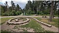
Children's rock spiral for balancing
Near the café at Haughmond Hill
Image: © TCExplorer
Taken: 24 Jun 2023
0.12 miles
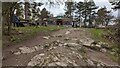
10
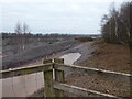
Glimpse into part of Haughmond Hill quarry
The rock quarried here was laid down around 550 million years ago at a time when 'Britain' was located 60 degrees south of the equator and was part of a super-continent called Gondwana, part of which broke away as tectonic plates shifted and moved inexorably northwards...
The oldest rocks here stood as volcanic mountains on the edge of a coastal plain, which was subjected to erosion, creating sand and pebbles. These were flushed down rivers into a network of rivers and estuaries and tumbled and churned, re-deposited etc.
At this far remote time in the Earth's history there were no animals or plants with hard skeletons or hard barks, so they left no fossils visible. However fossil ripples remained in shallow waters. These waters were constantly subjected to changing layouts as rivers moved their courses and the two types f rock quarried here were laid down: Conglomerate rock was made of ill-sorted but well rounded pebbles and sand that formed in meandering river channels. Secondly Greywacke a course sandstone formed with a clay matrix formed by flash flood events as rivers burst their banks and lots of fine material was deposited over large areas very quickly.
These flood plains later became covered in sea water, which retreated as the late Ordovician Ice Age developed, this led to further erosion and deposition as sea levels rose when the ice ages ended. By the mid-Silurian a tropical sea formed, with coastal reefs and Wenlock Limestone was deposited.
In time this led to an arid desert climate and the deposition of sandstones found in North and East Shropshire at Grinshill.
All of this was subject to massive pressures within the earth, which often folded hard horizontal rock layers, moving them to almost vertical planes, as found here, especially in the end wall of the quarry.
This was later covered by shallow seas, which morphed to deltas and lush tropical swamps, laying down what became coal measures, which were mined at nearby Uffington.
The Last Ice Age some 18,000 years ago caused glaciers and ice sheets to carve the rock and landscape and the Severn Valley formed, the river forming a gorge at Ironbridge.
Quarrying has occurred here on a large commercial scale since 1950, now used in motorway road surfacing as the stone in asphalt has skid-resistant qualities and is hard-wearing and long lasing.
Stone is blasted out, then subjected to primary crushing and then aggregate processing to grade the right sized rocks. Machines called Jaw Crushers and Cone Crushers which are mobile are used to get the perfect product.
Fascinating stuff. The quarry company are quick to point out that they have an exit plan and work hard to operate alongside farmers, landowners, the public and wildlife activists to ensure that wildlife thrives here.
Apparently the hill supports Muntjac Deer, Peregrine falcons. jackdaws, ravens and in a lagoon some fish.
I shared the viewing platform and info boards with a family with a young son who seemed impressed and threw some pebbles into an icy puddle to break the ice. Maybe one day he will work here or become a geologist, or even an environmental activist. Who knows?!?
Image: © Jeremy Bolwell
Taken: 7 Mar 2021
0.12 miles