IMAGES TAKEN NEAR TO
Sunningdale, SHREWSBURY, SY4 4RD
Introduction
This page details the photographs taken nearby to Sunningdale, SY4 4RD by members of the Geograph project.
The Geograph project started in 2005 with the aim of publishing, organising and preserving representative images for every square kilometre of Great Britain, Ireland and the Isle of Man.

There are currently over 7.5m images from over14,400 individuals and you can help contribute to the project by visiting https://www.geograph.org.uk
Image Map
Images are licensed for reuse under creativecommons.org/licenses/by-sa/2.0
Notes
- Clicking on the map will re-center to the selected point.
- The higher the marker number, the further away the image location is from the centre of the postcode.
Image Listing (5 Images Found)
Images are licensed for reuse under creativecommons.org/licenses/by-sa/2.0
Image
Details
Distance
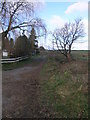
3
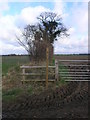
Which Way Bridleway
It is not clear which side of the hedge this bridleway passes, even to whoever erected the sign. Perhaps to the right?
Image: © Michael Patterson
Taken: 2 Feb 2007
0.17 miles
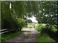
5
New and Old Tree
The tree to the right of this track is new growth from a mature stump.
Image: © Michael Patterson
Taken: 2 Feb 2007
0.24 miles