IMAGES TAKEN NEAR TO
Rodington Heath, Rodington, SHREWSBURY, SY4 4QZ
Introduction
This page details the photographs taken nearby to SY4 4QZ by members of the Geograph project.
The Geograph project started in 2005 with the aim of publishing, organising and preserving representative images for every square kilometre of Great Britain, Ireland and the Isle of Man.

There are currently over 7.5m images from over14,400 individuals and you can help contribute to the project by visiting https://www.geograph.org.uk
Image Map
Images are licensed for reuse under creativecommons.org/licenses/by-sa/2.0
Notes
- Clicking on the map will re-center to the selected point.
- The higher the marker number, the further away the image location is from the centre of the postcode.
Image Listing (6 Images Found)
Images are licensed for reuse under creativecommons.org/licenses/by-sa/2.0
Image
Details
Distance
3
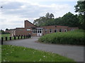
Rodington Post Office
The P.O. and village store is in the parish hall.
Image: © Richard Webb
Taken: 2 Jul 2014
0.20 miles
4
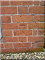
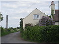
OS benchmark - Rodington, former Methodist Chapel
An OS cutmark at the NE angle of the former chapel, which is now converted to a private house; originally levelled at 58.766m above Ordnance Datum Newlyn.
Image: © Richard Law
Taken: 25 Jan 2015
0.21 miles
5
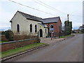
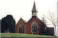
The former Methodist Chapel at Rodington
The chapel dates from 1834, and has a benchmark on the brickwork of the gable end on the right. It is now a private residence.
Image: © Richard Law
Taken: 25 Jan 2015
0.21 miles