IMAGES TAKEN NEAR TO
Gilbert Mount, SHREWSBURY, SY4 4QR
Introduction
This page details the photographs taken nearby to Gilbert Mount, SY4 4QR by members of the Geograph project.
The Geograph project started in 2005 with the aim of publishing, organising and preserving representative images for every square kilometre of Great Britain, Ireland and the Isle of Man.

There are currently over 7.5m images from over14,400 individuals and you can help contribute to the project by visiting https://www.geograph.org.uk
Image Map
Images are licensed for reuse under creativecommons.org/licenses/by-sa/2.0
Notes
- Clicking on the map will re-center to the selected point.
- The higher the marker number, the further away the image location is from the centre of the postcode.
Image Listing (15 Images Found)
Images are licensed for reuse under creativecommons.org/licenses/by-sa/2.0
Image
Details
Distance
1
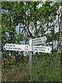
Direction Sign - Signpost in Rodington
Annulus finial - 3 arms; Shropshire CC modern halo by the UC road, in parish of Rodington (Telford and Wrekin District), Rodington.
Surveyed
Milestone Society National ID: SA_SJ5814
Image: © Milestone Society
Taken: Unknown
0.08 miles
2
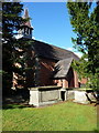
St George's church, Rodington
Grade II listed https://www.britishlistedbuildings.co.uk/101352000-church-of-st-george-rodington#.WZLmBFV96M8 in 1983, and built in the 1850s.
Image: © Richard Law
Taken: 4 Aug 2017
0.09 miles
4
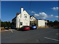
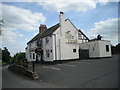
The Bull's Head at Rodington
Grade II listed https://www.britishlistedbuildings.co.uk/101033302-bulls-head-public-house-rodington#.WZLk_VV96M8 in 1983, the main part of the pub dates from the late 18th or early 19th century, although the timber-framed section seen here above the much more modern rectangular extension is likely to be 17th century.
Image: © Richard Law
Taken: 4 Aug 2017
0.10 miles
5
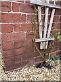
OS benchmark - Rodington, former school house
An OS cutmark on the wall of the former school house in Rodington; originally levelled at 54.501m above Ordnance Datum Newlyn.
Image: © Richard Law
Taken: 25 Jan 2015
0.11 miles
7
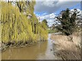
River Roden at Rodington
Road bridge into Rodington crosses the small River Roden. Today it was in full flow from snow melt and recent rainfall, but the spring greening of the weeping willow signals warmer days on their way.
Image: © Andrew Shannon
Taken: 14 Mar 2023
0.13 miles
8
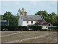
'The Villa' at Rodington
Seen here from some distance away to the north; The Villa is described as an early 19th Century red-brick house, and was Grade II listed https://www.britishlistedbuildings.co.uk/101292608-the-villa-rodington#.WZLjr1V96M8 in 1983.
Image: © Richard Law
Taken: 4 Aug 2017
0.14 miles
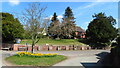
9
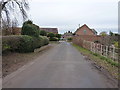
Rodington from the south
The approach to the village from a minor lane to the south.
Image: © Richard Law
Taken: 25 Jan 2015
0.14 miles
10
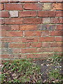
OS benchmark - Rodington, farm building
An OS cutmark on the wall of a small barn facing onto the lane towards Grove Farm; originally levelled at 55.986m above Ordnance Datum Newlyn.
Image: © Richard Law
Taken: 25 Jan 2015
0.15 miles