IMAGES TAKEN NEAR TO
Walcot Road, SHREWSBURY, SY4 4QQ
Introduction
This page details the photographs taken nearby to Walcot Road, SY4 4QQ by members of the Geograph project.
The Geograph project started in 2005 with the aim of publishing, organising and preserving representative images for every square kilometre of Great Britain, Ireland and the Isle of Man.

There are currently over 7.5m images from over14,400 individuals and you can help contribute to the project by visiting https://www.geograph.org.uk
Image Map
Images are licensed for reuse under creativecommons.org/licenses/by-sa/2.0
Notes
- Clicking on the map will re-center to the selected point.
- The higher the marker number, the further away the image location is from the centre of the postcode.
Image Listing (5 Images Found)
Images are licensed for reuse under creativecommons.org/licenses/by-sa/2.0
Image
Details
Distance
1
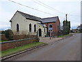
The former Methodist Chapel at Rodington
The chapel dates from 1834, and has a benchmark on the brickwork of the gable end on the right. It is now a private residence.
Image: © Richard Law
Taken: 25 Jan 2015
0.04 miles
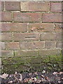
3
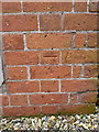
OS benchmark - Rodington, former Methodist Chapel
An OS cutmark at the NE angle of the former chapel, which is now converted to a private house; originally levelled at 58.766m above Ordnance Datum Newlyn.
Image: © Richard Law
Taken: 25 Jan 2015
0.05 miles
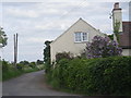
4
Villa Farm
One of several farms in the good fields around here; sugar beet was the normal crop for many years until British Sugar closed the nearby beet factory in Allscott in 2007/2008, since when it's been wheat, barley and other cereal crops that have predominated.
Image: © Richard Law
Taken: 25 Jan 2015
0.24 miles
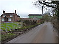
5
OS benchmark - Villa Farm
An OS cutmark on the wall of an outbuilding at Villa Farm; originally levelled at 54.27m above Ordnance Datum Newlyn.
Image: © Richard Law
Taken: 25 Jan 2015
0.25 miles