IMAGES TAKEN NEAR TO
Rodington, SHREWSBURY, SY4 4QL
Introduction
This page details the photographs taken nearby to SY4 4QL by members of the Geograph project.
The Geograph project started in 2005 with the aim of publishing, organising and preserving representative images for every square kilometre of Great Britain, Ireland and the Isle of Man.

There are currently over 7.5m images from over14,400 individuals and you can help contribute to the project by visiting https://www.geograph.org.uk
Image Map
Images are licensed for reuse under creativecommons.org/licenses/by-sa/2.0
Notes
- Clicking on the map will re-center to the selected point.
- The higher the marker number, the further away the image location is from the centre of the postcode.
Image Listing (12 Images Found)
Images are licensed for reuse under creativecommons.org/licenses/by-sa/2.0
Image
Details
Distance
1
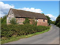
Listed stable range at Rodington
Dating from the 16th or 17th Century, this stable block was given a Grade II listing https://www.britishlistedbuildings.co.uk/101033301-stables-south-east-of-remains-of-rodington-hall-rodington#.WZPkUlV96M8 in 1983, and is presumably part of the original Rodington Hall farm buildings. The redbrick facing on the far end is a C19th addition.
Image: © Richard Law
Taken: 4 Aug 2017
0.03 miles
2
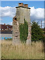
The sad remains of Rodington Hall
The 2-storey brick and sandstone chimney here is all that remains of the former 16th century Rodington Hall, which burnt to the ground in the 19th. This was Grade II listed https://www.britishlistedbuildings.co.uk/101209514-remains-of-rodington-hall-rodington#.WZLmn1V96M8 in 1983
Image: © Richard Law
Taken: 4 Aug 2017
0.03 miles
3
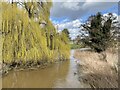
River Roden at Rodington
Road bridge into Rodington crosses the small River Roden. Today it was in full flow from snow melt and recent rainfall, but the spring greening of the weeping willow signals warmer days on their way.
Image: © Andrew Shannon
Taken: 14 Mar 2023
0.09 miles
4
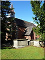
St George's church, Rodington
Grade II listed https://www.britishlistedbuildings.co.uk/101352000-church-of-st-george-rodington#.WZLmBFV96M8 in 1983, and built in the 1850s.
Image: © Richard Law
Taken: 4 Aug 2017
0.12 miles
6
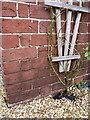
OS benchmark - Rodington, former school house
An OS cutmark on the wall of the former school house in Rodington; originally levelled at 54.501m above Ordnance Datum Newlyn.
Image: © Richard Law
Taken: 25 Jan 2015
0.13 miles
7
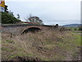
Disused canal bridge at Rodington
The bridge marks the route of the former Shrewsbury tub boat canal. This was a narrow-gauge canal, capable of carrying boats 6' wide with a 3' draught, which ran from the coalfields north of the area that is now Telford, to Shrewsbury. It opened in 1797, and became a branch of the Shropshire Union Canal in the 1840s, but suffered badly at the hands of the railway thereafter, and eventually closed in the 1920s. Relatively little remains of the canal these days, especially in the fields in this area, but this bridge and an embankment just east of here, plus the aqueduct at Longdon-on-Tern Image, and the warehouses at Wapenshall Image trace parts of the route from the Muxton area.
Image: © Richard Law
Taken: 25 Jan 2015
0.15 miles
8
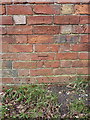
OS benchmark - Rodington, farm building
An OS cutmark on the wall of a small barn facing onto the lane towards Grove Farm; originally levelled at 55.986m above Ordnance Datum Newlyn.
Image: © Richard Law
Taken: 25 Jan 2015
0.15 miles
9
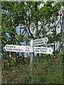
Direction Sign - Signpost in Rodington
Annulus finial - 3 arms; Shropshire CC modern halo by the UC road, in parish of Rodington (Telford and Wrekin District), Rodington.
Surveyed
Milestone Society National ID: SA_SJ5814
Image: © Milestone Society
Taken: Unknown
0.15 miles
10
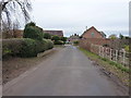
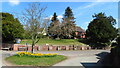
Rodington from the south
The approach to the village from a minor lane to the south.
Image: © Richard Law
Taken: 25 Jan 2015
0.15 miles