IMAGES TAKEN NEAR TO
Sandy Lane, SHREWSBURY, SY4 4PT
Introduction
This page details the photographs taken nearby to Sandy Lane, SY4 4PT by members of the Geograph project.
The Geograph project started in 2005 with the aim of publishing, organising and preserving representative images for every square kilometre of Great Britain, Ireland and the Isle of Man.

There are currently over 7.5m images from over14,400 individuals and you can help contribute to the project by visiting https://www.geograph.org.uk
Image Map
Images are licensed for reuse under creativecommons.org/licenses/by-sa/2.0
Notes
- Clicking on the map will re-center to the selected point.
- The higher the marker number, the further away the image location is from the centre of the postcode.
Image Listing (1 Images Found)
Images are licensed for reuse under creativecommons.org/licenses/by-sa/2.0
Image
Details
Distance
1
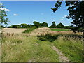
Former canal near Withington
Precious little remains visible of the former Shrewsbury Branch of the Shropshire Union Canal, which once ran through here, just to the south of Withington. The whole route ran from Norbury Junction in Image to a wharf in Shrewsbury beside the Image and was used to transport a variety of goods including stone, coal, iron ore and the like.
Image: © Richard Law
Taken: 18 Jul 2021
0.24 miles