IMAGES TAKEN NEAR TO
Downton, SHREWSBURY, SY4 4PL
Introduction
This page details the photographs taken nearby to Downton, SY4 4PL by members of the Geograph project.
The Geograph project started in 2005 with the aim of publishing, organising and preserving representative images for every square kilometre of Great Britain, Ireland and the Isle of Man.

There are currently over 7.5m images from over14,400 individuals and you can help contribute to the project by visiting https://www.geograph.org.uk
Image Map
Images are licensed for reuse under creativecommons.org/licenses/by-sa/2.0
Notes
- Clicking on the map will re-center to the selected point.
- The higher the marker number, the further away the image location is from the centre of the postcode.
Image Listing (14 Images Found)
Images are licensed for reuse under creativecommons.org/licenses/by-sa/2.0
Image
Details
Distance
1
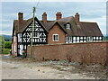
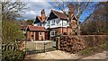
Downton Farmhouse
A rather splendid, if somewhat rambling, farmhouse just south of Haughmond Hill. The core of the building is likely to be late 16th century, but it's been much extended and altered over the years. Grade II* listed https://britishlistedbuildings.co.uk/101267697-downton-farmhouse-upton-magna#.YjxkaefP02w & https://historicengland.org.uk/listing/the-list/list-entry/1267697 in 1985. Comparison with a 2003 photo on the Historic England site suggests that several of the windows have been recently replaced in a much more sympathetic style than the previous version.
Image: © Richard Law
Taken: 21 Jul 2020
0.01 miles
3
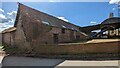
Large barn at Downton
The barn isn't listed but the nearby Downton Farmhouse is. Since 2011, there has been a Planning Application (granted) to convert these disused buildings into residential properties, but 12 years later there appears to be little activity.
Image: © TCExplorer
Taken: 27 Mar 2023
0.03 miles
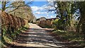
6
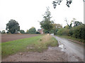
Near Downton Hall
Country lane between Upton Magna and Uffington. The quiet rural scene belies the fact that both a railway and the A5 trunk road cross the southern edge of this grid square.
Image: © Dennis Turner
Taken: 19 Oct 2005
0.16 miles
7
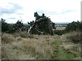
Lightning-blasted tree on Haughmond Hill
Apparently this tree was blasted in a thunderstorm. It looks suitably contorted, I must say.
Image: © Jeremy Bolwell
Taken: 13 Sep 2024
0.20 miles
8
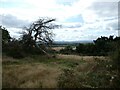
On the southern slopes of Haughmond Hill looking soutwards
The view here includes Caer Caradoc and the Stretton Gap.
Image: © Jeremy Bolwell
Taken: 13 Sep 2024
0.21 miles
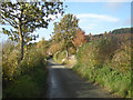
9
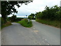
Junction of lanes near Downton
The upper road takes the NCN81 route towards Uffington and Shrewsbury, whilst the lower road to the left heads in the general direction of Preston, Berwick Wharf and Atcham.
Image: © Richard Law
Taken: 21 Jul 2020
0.22 miles
10
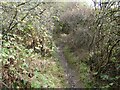
Twisting little footpath in a hilly copse below Haughmond Hill
Fun to follow.
Image: © Jeremy Bolwell
Taken: 13 Sep 2024
0.22 miles