IMAGES TAKEN NEAR TO
Woodlands Close, SHREWSBURY, SY4 4PJ
Introduction
This page details the photographs taken nearby to Woodlands Close, SY4 4PJ by members of the Geograph project.
The Geograph project started in 2005 with the aim of publishing, organising and preserving representative images for every square kilometre of Great Britain, Ireland and the Isle of Man.

There are currently over 7.5m images from over14,400 individuals and you can help contribute to the project by visiting https://www.geograph.org.uk
Image Map
Images are licensed for reuse under creativecommons.org/licenses/by-sa/2.0
Notes
- Clicking on the map will re-center to the selected point.
- The higher the marker number, the further away the image location is from the centre of the postcode.
Image Listing (19 Images Found)
Images are licensed for reuse under creativecommons.org/licenses/by-sa/2.0
Image
Details
Distance
1
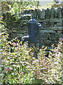
Water pump beside Caernarvon Road
Located just outside Image, this cast iron pump dates from the latter part of the 19th century, and was Grade II listed https://britishlistedbuildings.co.uk/101267602-pump-approximately-2-metres-to-south-east-of-number-3-withington#.YoXnTqjMI2w & https://historicengland.org.uk/listing/the-list/list-entry/1267602 in 1985.
Image: © Richard Law
Taken: 18 Jul 2021
0.09 miles
2
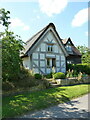
3 Caernarvon Road, Withington
With its origins in the 16th century, albeit subject to alterations since then, this rather attractive thatched cottage was Grade II listed https://britishlistedbuildings.co.uk/101223022-3-caernarvon-road-withington#.YoXow6jMI2w & https://historicengland.org.uk/listing/the-list/list-entry/1223022 in 1985. At the time of listing, the previous thatched roof was covered with corrugated sheeting, but that thatch has been renewed and the sheeting taken off.
Image: © Richard Law
Taken: 18 Jul 2021
0.09 miles
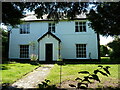
3
The Old Vicarage, Withington
19th and 20th century alterations disguise what is thought to be a late 16th or early 17th century house, primarily timber-framed on a rubble (sandstone?) plinth. The timberwork is apparently exposed in one of the gables, but clearly not this one. It was Grade II listed https://britishlistedbuildings.co.uk/101223126-the-old-vicarage-withington#.YnyyxujMI2w & https://historicengland.org.uk/listing/the-list/list-entry/1223126 in 1985.
Image: © Richard Law
Taken: 18 Jul 2021
0.10 miles
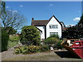
4
The Shrubbery, Withington
A house which rather hides its best features away, and lurks behind foliage at the front to boot. Despite appearances from this direction, it's actually an early-to-mid 17th century timber-framed building, with later extensions and modifications. It retains a number of interesting period features internally, such as a cooling shelf in the former dairy room, and fireplaces, doors and a staircase which date back to its early days. Grade II listed https://britishlistedbuildings.co.uk/101223162-the-shrubbery-withington#.Ynyv4-jMI2w & https://historicengland.org.uk/listing/the-list/list-entry/1223162 in 1985.
Image: © Richard Law
Taken: 18 Jul 2021
0.13 miles
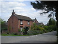
5
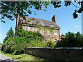
Manor Farmhouse, Withington
Built in 1710, and retaining a number of its original internal features such as fireplaces and staircase/balusters, this fine farmhouse was Grade II listed https://britishlistedbuildings.co.uk/101222790-manor-farmhouse-withington#.YoXtLajMI2w & https://historicengland.org.uk/listing/the-list/list-entry/1222790 in 1985.
Image: © Richard Law
Taken: 18 Jul 2021
0.14 miles
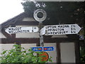
6
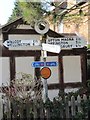
Old Direction Sign - Signpost in Withington
Annulus finial - 4 arms; Shropshire CC modern halo by the UC road, in parish of Withington (Shrewsbury And Atcham District), Withington.
Surveyed
Milestone Society National ID: SA_SJ5713.
Image: © Milestone Society
Taken: Unknown
0.15 miles
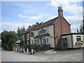
8
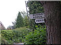
You've got to be joking
Yes, I am. The sign actually points to the Paris(h) Hall.
Image: © Row17
Taken: 20 May 2008
0.17 miles