IMAGES TAKEN NEAR TO
Bings Heath, SHREWSBURY, SY4 4DA
Introduction
This page details the photographs taken nearby to Bings Heath, SY4 4DA by members of the Geograph project.
The Geograph project started in 2005 with the aim of publishing, organising and preserving representative images for every square kilometre of Great Britain, Ireland and the Isle of Man.

There are currently over 7.5m images from over14,400 individuals and you can help contribute to the project by visiting https://www.geograph.org.uk
Image Map
Images are licensed for reuse under creativecommons.org/licenses/by-sa/2.0
Notes
- Clicking on the map will re-center to the selected point.
- The higher the marker number, the further away the image location is from the centre of the postcode.
Image Listing (9 Images Found)
Images are licensed for reuse under creativecommons.org/licenses/by-sa/2.0
Image
Details
Distance
1
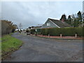
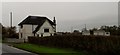
Housing at Bings Heath
A close or cul-de-sac I think.
Image: © Jeremy Bolwell
Taken: 30 Nov 2021
0.01 miles
2
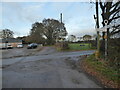
Road junction at Bings Heath
Old road sign. Nice.
Image: © Jeremy Bolwell
Taken: 30 Nov 2021
0.09 miles
3
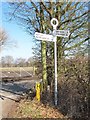
Old Direction Sign - Signpost by Bings Heath, Shawbury parish
Annulus finial - 3 arms; Shropshire CC modern halo by the UC road, in parish of Shawbury (North Shropshire District), Bings Heath.
Surveyed
Milestone Society National ID: SA_SJ5418
Image: © Milestone Society
Taken: Unknown
0.09 miles
5
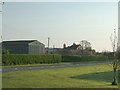
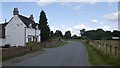
Farm at Bings Heath
Old Farm at Bings Heath nr Shrewsbury
Image: © Andy and Hilary
Taken: 22 Apr 2005
0.13 miles
6
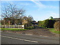
Bings Farm.
Entrance to Bings Farm,on the A53.
Image: © Paul Beaman
Taken: 29 Nov 2007
0.15 miles
9
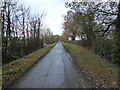
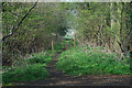
Narrow rural lane near Bings Heath
Interesting to trudge though.
Image: © Jeremy Bolwell
Taken: 30 Nov 2021
0.22 miles