IMAGES TAKEN NEAR TO
Upper Astley, Astley, SHREWSBURY, SY4 4BS
Introduction
This page details the photographs taken nearby to SY4 4BS by members of the Geograph project.
The Geograph project started in 2005 with the aim of publishing, organising and preserving representative images for every square kilometre of Great Britain, Ireland and the Isle of Man.

There are currently over 7.5m images from over14,400 individuals and you can help contribute to the project by visiting https://www.geograph.org.uk
Image Map
Images are licensed for reuse under creativecommons.org/licenses/by-sa/2.0
Notes
- Clicking on the map will re-center to the selected point.
- The higher the marker number, the further away the image location is from the centre of the postcode.
Image Listing (5 Images Found)
Images are licensed for reuse under creativecommons.org/licenses/by-sa/2.0
Image
Details
Distance
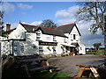
2
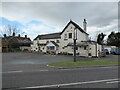
The Dog in the Lane public house at Upper Astley
Roadside inn but it looks closed.
Image: © Jeremy Bolwell
Taken: 30 Nov 2021
0.10 miles
3

Field edge footpath near Upper Astley
Heading towards Wheatley.
Image: © Jeremy Bolwell
Taken: 30 Nov 2021
0.21 miles
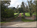
5
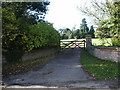
Entrance and drive to Astley House
Image: © Alexander P Kapp
Taken: 16 Oct 2007
0.25 miles