IMAGES TAKEN NEAR TO
Ladymas Road, SHREWSBURY, SY4 4AJ
Introduction
This page details the photographs taken nearby to Ladymas Road, SY4 4AJ by members of the Geograph project.
The Geograph project started in 2005 with the aim of publishing, organising and preserving representative images for every square kilometre of Great Britain, Ireland and the Isle of Man.

There are currently over 7.5m images from over14,400 individuals and you can help contribute to the project by visiting https://www.geograph.org.uk
Image Map
Images are licensed for reuse under creativecommons.org/licenses/by-sa/2.0
Notes
- Clicking on the map will re-center to the selected point.
- The higher the marker number, the further away the image location is from the centre of the postcode.
Image Listing (9 Images Found)
Images are licensed for reuse under creativecommons.org/licenses/by-sa/2.0
Image
Details
Distance
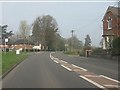
2
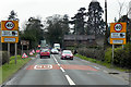
Autumn colour by A49, Hadnall
A road junction off the A49, to the north of Hadnall
Image: © David Smith
Taken: 20 Oct 2010
0.05 miles
3
Bus stop with timetable, Hadnall, by A49
Image: © David Smith
Taken: 4 Dec 2021
0.07 miles

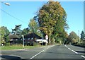
6
A49, Hadnall
Hadnall is a village and civil parish in Shropshire. It lies on the A49, approximately 5½ miles to the north-east of Shrewsbury. At the 2011 census, the population of the civil parish at the 2011 census was 688 (http://www.neighbourhood.statistics.gov.uk/dissemination/LeadKeyFigures.do?a=7&b=11124111&c=Hadnall&d=16&e=62&g=6460361&i=1001x1003x1032x1004&m=0&r=1&s=1470226764734&enc=1&nsjs=true&nsck=false&nssvg=false&nswid=1920 Office for National Statistics).
Image: © David Dixon
Taken: 11 Apr 2016
0.22 miles
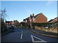
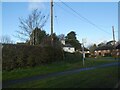
8

Shrewsbury Road, Hadnall
Hadnall is a village and civil parish in Shropshire. It lies on the A49, approximately 5½ miles to the north-east of Shrewsbury. At the 2011 census, the population of the civil parish at the 2011 census was 688 (http://www.neighbourhood.statistics.gov.uk/dissemination/LeadKeyFigures.do?a=7&b=11124111&c=Hadnall&d=16&e=62&g=6460361&i=1001x1003x1032x1004&m=0&r=1&s=1470226764734&enc=1&nsjs=true&nsck=false&nssvg=false&nswid=1920 Office for National Statistics).
Image: © David Dixon
Taken: 11 Apr 2016
0.23 miles
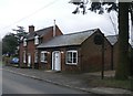
9
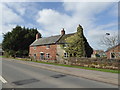
Part of Shrewsbury Road, Hadnall
With a traditional local cottage. The style in North Shropshire is more akin to Cheshire than the southern parts of the county. Nice too.
Image: © Jeremy Bolwell
Taken: 14 Apr 2018
0.24 miles