IMAGES TAKEN NEAR TO
Berwick, SHREWSBURY, SY4 3HN
Introduction
This page details the photographs taken nearby to SY4 3HN by members of the Geograph project.
The Geograph project started in 2005 with the aim of publishing, organising and preserving representative images for every square kilometre of Great Britain, Ireland and the Isle of Man.

There are currently over 7.5m images from over14,400 individuals and you can help contribute to the project by visiting https://www.geograph.org.uk
Image Map
Images are licensed for reuse under creativecommons.org/licenses/by-sa/2.0
Notes
- Clicking on the map will re-center to the selected point.
- The higher the marker number, the further away the image location is from the centre of the postcode.
Image Listing (5 Images Found)
Images are licensed for reuse under creativecommons.org/licenses/by-sa/2.0
Image
Details
Distance
1
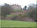
Berwick House viewed from across the Severn
Closer view of the impressive south-facing frontage.
Image: © Jeremy Bolwell
Taken: 4 Jan 2021
0.08 miles
2
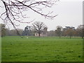
Berwick Chapel
The chapel, dated 1670, was built at the expense of Sir Samuel Jones and
stands in the parkland around Berwick House near to almshouses also built at the expense of Sir Samuel Jones. The chapel is listed Grade II*. https://britishlistedbuildings.co.uk/101366946-berwick-chapel-pimhill#.XLbCDOhKg2w
Image: © Eirian Evans
Taken: 7 Apr 2019
0.12 miles
3
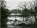
Berwick House
Looking at Berwick House from across the River Severn
Image: © Keith Havercroft
Taken: 12 Mar 2006
0.13 miles
5
Berwick House viewed from across the Severn
Impressive looking place indeed.
Image: © Jeremy Bolwell
Taken: 4 Jan 2021
0.24 miles