IMAGES TAKEN NEAR TO
Harmer Hill, SHREWSBURY, SY4 3DT
Introduction
This page details the photographs taken nearby to SY4 3DT by members of the Geograph project.
The Geograph project started in 2005 with the aim of publishing, organising and preserving representative images for every square kilometre of Great Britain, Ireland and the Isle of Man.

There are currently over 7.5m images from over14,400 individuals and you can help contribute to the project by visiting https://www.geograph.org.uk
Image Map (Loading...)


Getting Data...Please wait
Leaflet Map data © OpenStreetMap
Images are licensed for reuse under creativecommons.org/licenses/by-sa/2.0
Notes
- Clicking on the map will re-center to the selected point.
- The higher the marker number, the further away the image location is from the centre of the postcode.
Image Listing (20 Images Found)
Images are licensed for reuse under creativecommons.org/licenses/by-sa/2.0
Image
Details
Distance
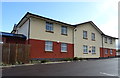
4
Car park, Premier Inn, Harmer Hill
Behind the southern block.
Image: © JThomas
Taken: 14 Mar 2019
0.15 miles
5
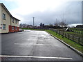
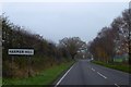
A528 towards Shrewsbury
The A528 at Harmer Hill
Image: © David Dixon
Taken: 31 May 2019
0.15 miles
6
Premier Inn, Harmer Hill
View of the southern block from the car park.
Image: © JThomas
Taken: 14 Mar 2019
0.16 miles
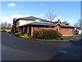
7
Premier Inn, Harmer Hill
Front of the southern block.
Image: © JThomas
Taken: 14 Mar 2019
0.16 miles
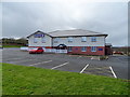
8
Premier Inn, Harmer Hill
The older northern block.
Image: © JThomas
Taken: 14 Mar 2019
0.17 miles
9
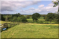
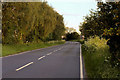
The southern edge of Harmer Hill
High hedges on the left and a windbreak on the right; this is agricultural country; in the distance are advance warning signs for the fork in the road in the village
Image: © David Smith
Taken: 28 Nov 2014
0.17 miles
10
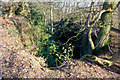
Quarry on Pim Hill
A bit of a shock, coming on this. It's clearly marked on the 25,000 map, though. There's shallower one 100 metres north, which is being used as a refuse tip.
Image: © Mike White
Taken: 28 Jan 2011
0.18 miles