IMAGES TAKEN NEAR TO
Battlefield, SHREWSBURY, SY4 3DB
Introduction
This page details the photographs taken nearby to SY4 3DB by members of the Geograph project.
The Geograph project started in 2005 with the aim of publishing, organising and preserving representative images for every square kilometre of Great Britain, Ireland and the Isle of Man.

There are currently over 7.5m images from over14,400 individuals and you can help contribute to the project by visiting https://www.geograph.org.uk
Image Map
Images are licensed for reuse under creativecommons.org/licenses/by-sa/2.0
Notes
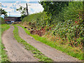
- Clicking on the map will re-center to the selected point.
- The higher the marker number, the further away the image location is from the centre of the postcode.
Image Listing (90 Images Found)
Images are licensed for reuse under creativecommons.org/licenses/by-sa/2.0
Image
Details
Distance
1
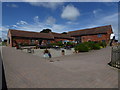
Battlefield 1403
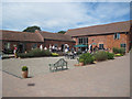
Butcher's, Deli and Cafe at the Farm Shop
Image: © Eirian Evans
Taken: 17 Jul 2016
0.01 miles
2
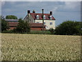
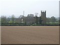
Battlefield Farm
Viewed across fields to the fore of St. Mary Magdalene church.
Image: © J Scott
Taken: 15 Jul 2011
0.01 miles
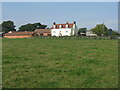
3
Battlefield 1403
Part of the Allbrighton Estate. A stone's throw from the site of the Battle of Shrewsbury.
Image: © Eirian Evans
Taken: 17 Jul 2016
0.02 miles
4
Battlefield Farm 1403
Farm shop and visitor centre near the site of the Battle of Shrewsbury [1403] http://en.wikipedia.org/wiki/Battle_of_Shrewsbury
Image: © M J Richardson
Taken: 28 Sep 2013
0.02 miles
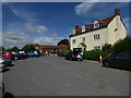
6
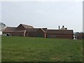
Outbuildings and farm shop at Battlefield Farm
Image: © John M
Taken: 24 Apr 2010
0.04 miles
7
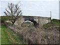
Railway Bridge at Battlefield Farm
Over the Shrewsbury to Crewe line.
Image: © John M
Taken: 24 Apr 2010
0.08 miles
9
Track near Battlefield Farm
A low-flying Harris Hawk from the nearby falconry centre is approaching, just above the farm track.
Image: © David Dixon
Taken: 20 Sep 2022
0.12 miles
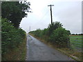
10
Battle of Shrewsbury - 1403 - 'the field of peas'
The battle took place on 21st July 1403 between a rebel army raised by the Percy family of Northumberland and King Henry IV supported by his son Prince Hal. The rebels had grievances over money owing following their part in the overthrow of Richard II in 1399 and later assistance to the king. The battle is notable for the large scale deployment of English archers in both of the armies and set the pattern for the victory against the French at Agincourt. It is thought that the rebel army may have numbered 10,000 and the royal army 14,000.
The rebel army took up positions on the hill, here, overlooking the later Battlefield Church. The Royal forces deployed on the lower ground near the new bypass approximately on the line of the electricity pylons before advancing and attacking uphill across a 'field of peas'.
The attack faltered encouraging Henry 'Hotspur' Percy to counter attack being slain by a blow in the process. A flanking move by Prince Hal carried the day for the King's army. The fiercest part of the battle took place in the area now marked by the church and many of the dead were said to be buried there in a mass grave.
The church was built in 1406 to mark the site of the battle.
Image: © John M
Taken: 24 Apr 2010
0.13 miles