IMAGES TAKEN NEAR TO
Brownhill, Ruyton XI Towns, SHREWSBURY, SY4 1LR
Introduction
This page details the photographs taken nearby to SY4 1LR by members of the Geograph project.
The Geograph project started in 2005 with the aim of publishing, organising and preserving representative images for every square kilometre of Great Britain, Ireland and the Isle of Man.

There are currently over 7.5m images from over14,400 individuals and you can help contribute to the project by visiting https://www.geograph.org.uk
Image Map
Images are licensed for reuse under creativecommons.org/licenses/by-sa/2.0
Notes
- Clicking on the map will re-center to the selected point.
- The higher the marker number, the further away the image location is from the centre of the postcode.
Image Listing (6 Images Found)
Images are licensed for reuse under creativecommons.org/licenses/by-sa/2.0
Image
Details
Distance
2
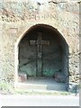
War Memorial
An unusual war memorial, carved out of the cliff face, providing seats to look at the list of the fallen on the walls inside.
Image: © David Luther Thomas
Taken: 28 Apr 2007
0.03 miles
3
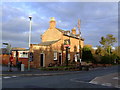
The Bridge, Ruyton XI Towns, Salop
Banks's pub closed earlier this year, but fortunately revived in July and now a fully rejuvenated, lively village / town by name, pub.
Image: © al partington
Taken: 9 Nov 2006
0.17 miles
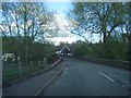
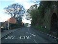
5
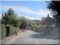
Approaching Platt Bridge
Road works in operation on B4397 for bridge repairs
Image: © John Firth
Taken: 25 Jul 2011
0.24 miles