IMAGES TAKEN NEAR TO
Forton Bank, SHREWSBURY, SY4 1ER
Introduction
This page details the photographs taken nearby to Forton Bank, SY4 1ER by members of the Geograph project.
The Geograph project started in 2005 with the aim of publishing, organising and preserving representative images for every square kilometre of Great Britain, Ireland and the Isle of Man.

There are currently over 7.5m images from over14,400 individuals and you can help contribute to the project by visiting https://www.geograph.org.uk
Image Map
Images are licensed for reuse under creativecommons.org/licenses/by-sa/2.0
Notes
- Clicking on the map will re-center to the selected point.
- The higher the marker number, the further away the image location is from the centre of the postcode.
Image Listing (26 Images Found)
Images are licensed for reuse under creativecommons.org/licenses/by-sa/2.0
Image
Details
Distance
1

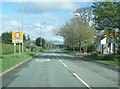
Road junction in Montford Bridge
Yup.
Pretty much a basic typical road junction, with a layout that one can see anywhere, but I like it.
Image: © Jeremy Bolwell
Taken: 22 Mar 2023
0.14 miles
2
B4380 at Montford Bridge village boundary
Image: © Colin Pyle
Taken: 22 Apr 2018
0.14 miles
3

Lon Cambria cycleway sign at Montford Bridge
This is apparently a cycle route linking Shrewsbury with Aberystwyth, https://cycle.travel/route/lon_cambria here.
Image: © Jeremy Bolwell
Taken: 22 Mar 2023
0.15 miles
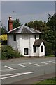
4
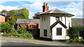
Old Toll House, Montford Bridge
Montford Bridge was rebuilt by Thomas Telford in 1792 as part of the improvements to the London to Holyhead road, which became the A5.
Image: © Humphrey Bolton
Taken: 21 Jun 2000
0.16 miles
5

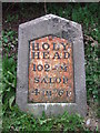
Old Milestone by the B4380, Holyhead Road, Montford Bridge
Metal plate attached to stone post by the B4380 (was A5), in parish of Montford (Shrewsbury and Atcham District), 125m South of Forton Cottage, in lay-by, on South side of road. Telford gabled iron plate, erected by the Holyhead Road turnpike trust in the 19th century.
Inscription reads:-
HOLY-
HEAD
102-M
SALOP
4 M-6F
Rivet benchmark on top.
Grade II listed.
List Entry Number: 1366941 https://historicengland.org.uk/listing/the-list/list-entry/1366941
Milestone Society National ID: SA_HH102
Image: © A Reade/J Higgins
Taken: 8 Jul 2008
0.16 miles
6
Old Milestone
Old milestone on what would have been the A.5 near to Montford Bridge, Shropshire. For overall view see http://www.geograph.org.uk/photo/4776103
Image: © Keith Evans
Taken: 17 Oct 2015
0.16 miles
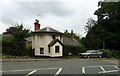
7
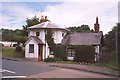
Old Toll House by Holyhead Road, Montford Bridge
Toll House in the parish of Montford, The Round House, No. 1, Holyhead Road, SY4 1ED.
Grade II listed.
List Entry Number: 1175719 https://historicengland.org.uk/listing/the-list/list-entry/1175719
To be surveyed
Milestone Society National ID: SA.MON
Image: © Milestone Society
Taken: Unknown
0.17 miles

9
Old Toll House, Montford Bridge
On the former A5.
Image: © JThomas
Taken: 4 Sep 2024
0.17 miles